IMAGES TAKEN NEAR TO
Whitchurch Way, COVENTRY, CV4 8DG
Introduction
This page details the photographs taken nearby to Whitchurch Way, CV4 8DG by members of the Geograph project.
The Geograph project started in 2005 with the aim of publishing, organising and preserving representative images for every square kilometre of Great Britain, Ireland and the Isle of Man.

There are currently over 7.5m images from over14,400 individuals and you can help contribute to the project by visiting https://www.geograph.org.uk
Image Map
Images are licensed for reuse under creativecommons.org/licenses/by-sa/2.0
Notes
- Clicking on the map will re-center to the selected point.
- The higher the marker number, the further away the image location is from the centre of the postcode.
Image Listing (25 Images Found)
Images are licensed for reuse under creativecommons.org/licenses/by-sa/2.0
Image
Details
Distance
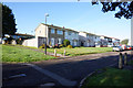
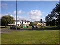
2
Whitchurch Way, Canley
At the junction with Wolfe Road.
Image: © John Brightley
Taken: 31 Aug 2010
0.05 miles
5
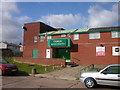
Canley Sports and Social Club
In Marler Road
Image: © Ian Rob
Taken: 25 Sep 2005
0.09 miles
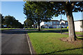
6
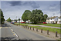
Charter Avenue Coventry
Charter Avenue has many blocks of flats along its length. It is a spacious looking road which leads to Charter industrial estate.
Image: © Malcolm Neal
Taken: 28 May 2017
0.10 miles
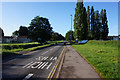
7
Canley-Charter Avenue
At the junction with Wolfe Road.
Image: © Ian Rob
Taken: 25 Sep 2005
0.12 miles
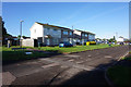
9
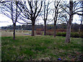
Former Alderman Harris school
The site of Alderman Harris primary school, which was merged with Sir Henry Parkes school to become Charter School on a new site at the bottom of Mitchell Avenue. Both former schools were closed and demolished.
Image: © E Gammie
Taken: 16 Apr 2012
0.12 miles
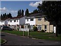
10
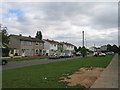
Scarborough Way, Canley, Coventry
The spaciously laid out development of factory manufactured housing lies between Charter Avenue and the Coventry - Birmingham main line.
Image: © David Stowell
Taken: 29 Aug 2005
0.14 miles