IMAGES TAKEN NEAR TO
Jacob Drive, COVENTRY, CV4 7JT
Introduction
This page details the photographs taken nearby to Jacob Drive, CV4 7JT by members of the Geograph project.
The Geograph project started in 2005 with the aim of publishing, organising and preserving representative images for every square kilometre of Great Britain, Ireland and the Isle of Man.

There are currently over 7.5m images from over14,400 individuals and you can help contribute to the project by visiting https://www.geograph.org.uk
Image Map
Images are licensed for reuse under creativecommons.org/licenses/by-sa/2.0
Notes
- Clicking on the map will re-center to the selected point.
- The higher the marker number, the further away the image location is from the centre of the postcode.
Image Listing (123 Images Found)
Images are licensed for reuse under creativecommons.org/licenses/by-sa/2.0
Image
Details
Distance
1
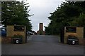
Entrance to Canley Crematorium and Garden Cemetery
Image: © Keith Williams
Taken: 2 May 2008
0.03 miles
2
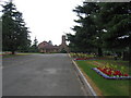
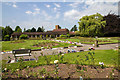
Canley Cemetery
The cemetery covers much of the northern part of this square. The picture shows the main cemetery buildings and some of the well maintained gardens.
Image: © David Stowell
Taken: 23 Jul 2005
0.04 miles
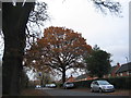
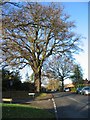
4
Cannon Hill Road
A somewhat frantic looking tree, having undergone what I think is termed 'crown reduction'.
Image: © E Gammie
Taken: 18 Feb 2021
0.05 miles
5
Cannon Hill Road
A tree near the Jacob Drive junction has been reduced and, from a comparison with Image], it looks like the tree across the road has lost some weight, too.
Image: © E Gammie
Taken: 18 Feb 2021
0.05 miles
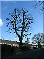
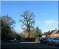
6
Oak, Cannon Hill Road
The junction with Jacob Drive in the foreground, left.
Image: © E Gammie
Taken: 6 Dec 2009
0.06 miles
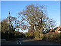
7
Oak, Cannon Hill Road
The junction with Ivy Farm Lane in the foreground, left.
According to the Woodland Trust ancient tree site, this tree has been recorded by the Warwickshire Biological Records Centre as a veteran pedunculate oak (tree no. 80351).
Image: © E Gammie
Taken: 6 Dec 2009
0.06 miles
8
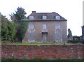
Empty house, Ivy Farm Lane
This was Canley Hall and under the pebble-dashing and shuttering is an early 18th century or earlier building.
Image: © E Gammie
Taken: 30 Mar 2008
0.07 miles
9
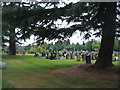
Canley Crematorium & Garden Cemetery
View NNW over the garden of remembrance towards the crematorium and chapels. http://www.coventry.gov.uk/directory_record/28/canley_garden_cemetery_and_crematorium
Image: © David P Howard
Taken: 23 Jul 2014
0.07 miles
10
Canley Garden Cemetery
Part of the graves section of the cemetery and crematorium.
Image: © E Gammie
Taken: 30 Jun 2017
0.08 miles