IMAGES TAKEN NEAR TO
Aldrin Way, COVENTRY, CV4 7DP
Introduction
This page details the photographs taken nearby to Aldrin Way, CV4 7DP by members of the Geograph project.
The Geograph project started in 2005 with the aim of publishing, organising and preserving representative images for every square kilometre of Great Britain, Ireland and the Isle of Man.

There are currently over 7.5m images from over14,400 individuals and you can help contribute to the project by visiting https://www.geograph.org.uk
Image Map
Images are licensed for reuse under creativecommons.org/licenses/by-sa/2.0
Notes
- Clicking on the map will re-center to the selected point.
- The higher the marker number, the further away the image location is from the centre of the postcode.
Image Listing (20 Images Found)
Images are licensed for reuse under creativecommons.org/licenses/by-sa/2.0
Image
Details
Distance
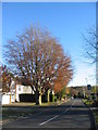
1
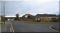
Aldrin Way and Lunar Close
Looking along Aldrin Way, with Lunar Close off to the right. A small area of Canley named after Buzz Aldrin, Apollo 11 lunar module pilot.
Image: © E Gammie
Taken: 27 Nov 2016
0.04 miles
2
Aldrin Way, leading to Collins Grove
A small area of Canley named after two of the Apollo 11 astronauts, Buzz Aldrin and Michael Collins.
Image: © E Gammie
Taken: 27 Nov 2016
0.06 miles
3
Near Bransford Avenue
A cycle and pedestrian link between Cannon Hill Road and Bransford Avenue
Image: © E Gammie
Taken: 5 Dec 2015
0.07 miles
4
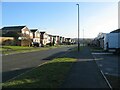
De Montfort Way, Cannon Park
A c. 1970s/80s housing development adjacent to the University of Warwick campus.
Image: © E Gammie
Taken: 6 Feb 2021
0.08 miles
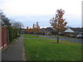
5
Beeches, Cannon Hill Road
A pair of beech trees with substantial diameter trunks alongside Cannon Hill Road.
Image: © E Gammie
Taken: 28 Nov 2016
0.15 miles
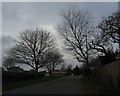
6
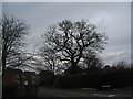
Oak, Lilacvale Way
A mature oak tree near the junction of Lilacvale Way cul-de-sac and Cannon Hill Road.
Image: © E Gammie
Taken: 5 Dec 2015
0.15 miles
7
Willow sculpture, University of Warwick campus
'Don't Let Go', a willow sculpture created by Laura Ellen Bacon in 2019 alongside a path at the edge of the campus. One of several sculptures of the University of Warwick Art Collection dotted around the campus.
Image: © E Gammie
Taken: 11 Apr 2021
0.18 miles
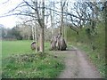
8
Shultern Lane
This is the western end of the lane, which is closed to motor traffic.
Image: © Keith Williams
Taken: 2 May 2008
0.19 miles
9
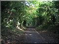
Shultern Lane, Canley
Once a country lane, now a pedestrian and cycle route between Cannon Park shops and Cannon Hill Road. Here, the greenery hides the cemetery on the left and housing on the right.
Image: © E Gammie
Taken: 19 Sep 2015
0.19 miles
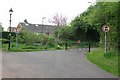
10
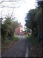
Shultern Lane and Ivy Farm Lane
The junction of Shultern Lane (foreground) with the end of Ivy Farm Lane. The building at the junction is Canley Hall Farm cottages, originally a farmhouse. Shultern Lane is closed to traffic other than cycle and pedestrian.
Image: © E Gammie
Taken: 30 Mar 2008
0.20 miles