IMAGES TAKEN NEAR TO
Bockendon Road, COVENTRY, CV4 7DB
Introduction
This page details the photographs taken nearby to Bockendon Road, CV4 7DB by members of the Geograph project.
The Geograph project started in 2005 with the aim of publishing, organising and preserving representative images for every square kilometre of Great Britain, Ireland and the Isle of Man.

There are currently over 7.5m images from over14,400 individuals and you can help contribute to the project by visiting https://www.geograph.org.uk
Image Map
Images are licensed for reuse under creativecommons.org/licenses/by-sa/2.0
Notes
- Clicking on the map will re-center to the selected point.
- The higher the marker number, the further away the image location is from the centre of the postcode.
Image Listing (9 Images Found)
Images are licensed for reuse under creativecommons.org/licenses/by-sa/2.0
Image
Details
Distance
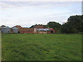
1
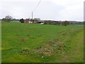
Bockenden Grange
This relatively modern building is a few hundred metres from a moated site in the north east corner of the square which was the original site of Bockidene Grange and which is now occupied by an even more modern house.
In 1928, the then current Lord Leigh sold off a lot of the Stoneleigh Estate. One of the farms sold was Bockenden Grange Farm. The Auctioneers catalogue listed Bockendon Grange as Lot
No 35 and described it thus:
"A Compact Mixed Farm, known as Bockendon Grange Farm, comprising an old-fashioned House, range of brick and tiled Buildings and closes of fertile, arable and sound pasture land, the whole extending to an area of 177 acres, 1 rod and 33 perches or thereabouts. The Residence is situate a convenient distance off the road, is in good repair, and contains the following accommodation:- Porch, tiled Entrance Hall, Drawing Room, 15ft 9in by 13ft, with fireplace and marble mantel, Breakfast Room, 15ft 3in by 10ft, Dining Room, 16ft 9in by 14ft, with ingle nook, China Pantry, Larder, excellent Dairy, Kitchen, with copper and sink, cellar. On the First Floor, approached by front and back Staircases, are Landing, five Bedrooms, Boxroom, and Bathroom. (Bath, lavatory basin, tank, fittings and partitions are claimed by the Tenant.) Covered Yard with Wash-house, with copper and sink, Pump and Closet. Well kept Gardens include Kitchen Garden, Pleasure Garden, with Lawn and Orchard. The Farm Buildings are conveniently placed and include:- Range of nine Duck Pens, two Calf Pens, Cowshed for six and Calf Pen, Loose Box with Loft over, Carthorse Stable for five with part loft over, Engine Shed, Cowshed for 13, two-bay open Feeding Shed and Yard, four pigstyes, Workmen's Bothy with two rooms over, two Loose Boxes, Calf Pen, Three-span Four-bay DUTCH BARN, three-bay lean-to Cart Shed, two-bay Wagon Hovel, Trap Shed and
Rickyard. There is a Water Trough in the yard.
Let to Mr Thomas Lea, together with other land, on an Annual Ladyday
Tenancy, at an apportioned rent of £292 10s 0d per annum."
Image: © Nigel Mykura
Taken: 6 Mar 2011
0.02 miles
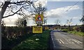
3
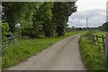
A country Lane outside Coventry
The back road from Coventry to Kenilworth passes this quiet country road.
Image: © Malcolm Neal
Taken: 27 May 2017
0.08 miles
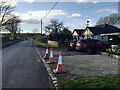
4
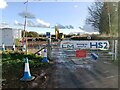
HS2 enabling works, Crackley-Burton Green, March 2021 (13)
At the sharp bend of Crackley Lane Image there is this contractor's compound with access to the preliminary works east of Burton Green.
Image: © Robin Stott
Taken: 26 Mar 2021
0.11 miles
5
HS2 enabling works, Crackley-Burton Green, March 2021 (12)
To the left of the sharp bend of Crackley Lane there is a contractor's compound and access to the preliminary works east of Burton Green Image Photographed on 26 March, a Friday, yet the road is open despite the notification of closure from 23 March.
Image: © Robin Stott
Taken: 26 Mar 2021
0.11 miles
6
Approaching HS2 site access, Crackley Lane, near Westwood Heath
The site access, signed further along the road, is seen in Image
Image: © Robin Stott
Taken: 26 Mar 2021
0.14 miles
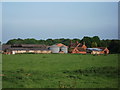
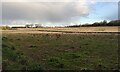
7
Bockendon Grange
Seen looking SE from the footpath across this square.
Image: © David Stowell
Taken: 27 Aug 2005
0.15 miles
8
HS2 enabling works, Crackley-Burton Green, March 2021 (14)
The defined route, or at least the haul road, nears Burton Green from the southeast. Broadwells Wood is in the distance, left Image The trees on the right flank the Kenilworth Greenway, a public bridleway created on a disused railway line. The view continues to the right in Image
Image: © Robin Stott
Taken: 26 Mar 2021
0.23 miles
9
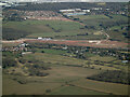
HS2 construction site at Burton Green from the air
Burton Green is in the foreground, Westwood Heath and the Network Rail conference centre are in the distance. Viewed from a Birmingham bound flight from Prague.
Image: © Thomas Nugent
Taken: 11 Feb 2022
0.24 miles