IMAGES TAKEN NEAR TO
Atherston Place, COVENTRY, CV4 7BY
Introduction
This page details the photographs taken nearby to Atherston Place, CV4 7BY by members of the Geograph project.
The Geograph project started in 2005 with the aim of publishing, organising and preserving representative images for every square kilometre of Great Britain, Ireland and the Isle of Man.

There are currently over 7.5m images from over14,400 individuals and you can help contribute to the project by visiting https://www.geograph.org.uk
Image Map
Images are licensed for reuse under creativecommons.org/licenses/by-sa/2.0
Notes
- Clicking on the map will re-center to the selected point.
- The higher the marker number, the further away the image location is from the centre of the postcode.
Image Listing (184 Images Found)
Images are licensed for reuse under creativecommons.org/licenses/by-sa/2.0
Image
Details
Distance
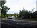
1
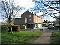
Cannon Hill Road shops
A short parade of shops, with living space above, off Cannon Hill Road.
Image: © E Gammie
Taken: 26 Mar 2021
0.02 miles
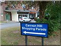
2
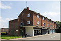
Cannon Hill Shopping Parade
A row of shops off Cannon Hill Road.
Image: © David P Howard
Taken: 23 Jul 2014
0.02 miles
4
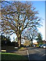
Oak, Cannon Hill Road
The junction with Ivy Farm Lane in the foreground, left.
According to the Woodland Trust ancient tree site, this tree has been recorded by the Warwickshire Biological Records Centre as a veteran pedunculate oak (tree no. 80351).
Image: © E Gammie
Taken: 6 Dec 2009
0.06 miles
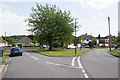
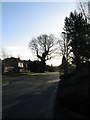
5
Hilary Road
Looking across Cannon Hill Road towards Hilary Road from the end of Cannocks Lane. The trees in the distance border Kenilworth Road (A429).
Image: © E Gammie
Taken: 17 Oct 2013
0.07 miles
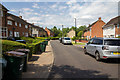
6
Hilary Road
View ESE along Hilary Road towards the junction with Merynton Avenue.
Image: © David P Howard
Taken: 23 Jul 2014
0.07 miles
7
Pershore Place
Looking north up Pershore Place towards the junction with Orlescote Road, on dustbin day.
Image: © David P Howard
Taken: 23 Jul 2014
0.08 miles
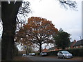
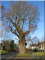
9
Oaks, Cannon Hill Road
A gnarled old oak silhouetted against the afternoon sun. The junction with Hilary Road in the foreground, left.
Image: © E Gammie
Taken: 6 Dec 2009
0.08 miles
10
Oak, Cannon Hill Road
A gnarled old specimen, near the junction with Hilary Road.
According to the Woodland Trust ancient tree site, this tree has been recorded by the Warwickshire Biological Records Centre as a veteran pedunculate oak (tree no. 80423).
Image: © E Gammie
Taken: 6 Dec 2009
0.08 miles