IMAGES TAKEN NEAR TO
Leighton Close, COVENTRY, CV4 7AE
Introduction
This page details the photographs taken nearby to Leighton Close, CV4 7AE by members of the Geograph project.
The Geograph project started in 2005 with the aim of publishing, organising and preserving representative images for every square kilometre of Great Britain, Ireland and the Isle of Man.

There are currently over 7.5m images from over14,400 individuals and you can help contribute to the project by visiting https://www.geograph.org.uk
Image Map
Images are licensed for reuse under creativecommons.org/licenses/by-sa/2.0
Notes
- Clicking on the map will re-center to the selected point.
- The higher the marker number, the further away the image location is from the centre of the postcode.
Image Listing (41 Images Found)
Images are licensed for reuse under creativecommons.org/licenses/by-sa/2.0
Image
Details
Distance
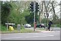
1
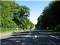
Kenilworth Road at Gibbet Hill
Kenilworth Road has been closed from this point to Cannon Hill Road junction whilst runners in the Coventry half marathon pass through (you may be able to spot them in the shade). Over 8 miles gone, and it's all downhill from here (well, mostly).
Image: © E Gammie
Taken: 23 May 2010
0.06 miles
2
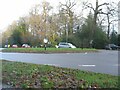
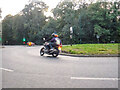
Gibbet Hill, Kenilworth Road
The roundabout at Gibbet Hill crossroads, built in 2015 to replace the previous traffic-light controls.
Image: © E Gammie
Taken: 20 Dec 2020
0.09 miles
3
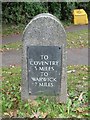
Old Milestone by Gibbet Hill Road, Kenilworth Road Junction, Coventry Parish
Metal plate attached to stone post by the A429, in parish of COVENTRY (COVENTRY District), Gibbet Hill Road, at junction with Kenilworth Road; 2ft from kerb by stop line for traffic lights, on North side of road. Erected by the Coventry & Warwick turnpike trust in the 20th century.
Inscription reads:-
TO
COVENTRY
3 MILES
TO WARWICK
7 MILES
Milestone Society National ID: WA_CVWA03R
Image: © Mike Faherty
Taken: 4 Oct 2008
0.09 miles
4
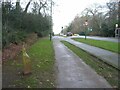
Kenilworth Road
Looking towards the crossroads with Gibbet Hill Road and Stoneleigh Road. The post in the foreground marks the boundary between the City of Coventry and the Parish of Stoneleigh as it was when the city's boundary was extended in 1928. The current boundary crosses the road some 500-600 metres further south-west.
Image: © E Gammie
Taken: 20 Dec 2020
0.09 miles
5
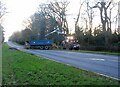
Tree debris removal, Kenilworth Road
Workers removing tree debris blocking the road, the result of the upper parts of a tree in the spinney alongside the road being snapped off by strong winds associated with Storm Franklin. Trunk-sized debris is being loaded into a trailer by the tractor and grabber. In the background there is a wood chipper to deal with smaller branches that have been chain-sawed off. The road was temporarily closed between Gibbet Hill Road (in the background) and Cannon Hill Road junctions.
Image: © E Gammie
Taken: 21 Feb 2022
0.10 miles
6
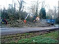
Tree debris removal, Kenilworth Road (2)
Workers dealing with the upper parts of a tree which had been snapped off by strong winds associated with Storm Franklin. A worker is chain-sawing off branches ready to feed to the chipper on the left whilst larger parts are loaded into the trailer by the grabber. The road was temporarily closed between Gibbet Hill Road and Cannon Hill Road junctions.
Image: © E Gammie
Taken: 21 Feb 2022
0.10 miles
7
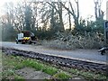
Tree debris removal, Kenilworth Road (3)
The upper branches of a tree damaged by strong winds associated with Storm Franklin await their fate by the wood chipper. The snapped-off trunk of the tree can be seen on the right.
Image: © E Gammie
Taken: 21 Feb 2022
0.10 miles
8
Gibbet Hill : Kenilworth Road A429
A roundabout on Kenilworth Road.
Image: © Lewis Clarke
Taken: 25 Sep 2021
0.10 miles
9
Junction of Gibbet Hill Road and Kenilworth Road
Image: © Keith Williams
Taken: 2 May 2008
0.10 miles
10
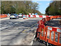
Road works at Gibbet Hill crossroads
Constructing a new roundabout at the busy crossroads.
Image: © Mat Fascione
Taken: 18 Apr 2015
0.11 miles