IMAGES TAKEN NEAR TO
Gaydon Road, SOUTHAM, CV47 2QZ
Introduction
This page details the photographs taken nearby to Gaydon Road, CV47 2QZ by members of the Geograph project.
The Geograph project started in 2005 with the aim of publishing, organising and preserving representative images for every square kilometre of Great Britain, Ireland and the Isle of Man.

There are currently over 7.5m images from over14,400 individuals and you can help contribute to the project by visiting https://www.geograph.org.uk
Image Map
Images are licensed for reuse under creativecommons.org/licenses/by-sa/2.0
Notes
- Clicking on the map will re-center to the selected point.
- The higher the marker number, the further away the image location is from the centre of the postcode.
Image Listing (5 Images Found)
Images are licensed for reuse under creativecommons.org/licenses/by-sa/2.0
Image
Details
Distance
1
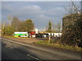
Tyre sales
This is the entrance to the "works" marked on the map near Bishop's Itchington. The main advertised activity seems to be tyre sales, with agricultural varieties a speciality.
Image: © David Stowell
Taken: 23 Dec 2005
0.02 miles
2
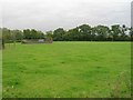
Demolished building in field east of Gaydon Road
View SE from the B4451 Gaydon Road, across a field, towards the remains of a demolished building.
Image: © David P Howard
Taken: 24 Sep 2010
0.05 miles
3
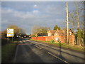
Gaydon Road approaching Cross Green
Seen as the Gaydon Road crosses into the next square and lit by a low winter sun. The signs dramatically alert drivers to the bend ahead, although judging by the state of some of them not everyone takes notice!
Image: © David Stowell
Taken: 23 Dec 2005
0.05 miles
4
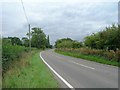
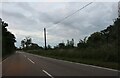
B4451 Gaydon Road
Looking SSW along Gaydon Road just after it leaves Bishop's Itchington, towards Brookside Farm.
Image: © David P Howard
Taken: 24 Sep 2010
0.10 miles