IMAGES TAKEN NEAR TO
School Lane, SOUTHAM, CV47 2BU
Introduction
This page details the photographs taken nearby to School Lane, CV47 2BU by members of the Geograph project.
The Geograph project started in 2005 with the aim of publishing, organising and preserving representative images for every square kilometre of Great Britain, Ireland and the Isle of Man.

There are currently over 7.5m images from over14,400 individuals and you can help contribute to the project by visiting https://www.geograph.org.uk
Image Map (Loading...)


Getting Data...Please wait
Leaflet Map data © OpenStreetMap
Images are licensed for reuse under creativecommons.org/licenses/by-sa/2.0
Notes
- Clicking on the map will re-center to the selected point.
- The higher the marker number, the further away the image location is from the centre of the postcode.
Image Listing (35 Images Found)
Images are licensed for reuse under creativecommons.org/licenses/by-sa/2.0
Image
Details
Distance
1
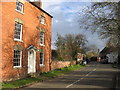
Ladbroke main street
Looking south through the centre of the village. At one time this was the busy Southam - Banbury trunk road, but tranquillity was restored when a bypass was built. The daffs are starting to appear in early spring.
Image: © David Stowell
Taken: 30 Mar 2006
0.04 miles
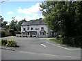
2
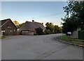
School Lane at the junction of Banbury Road, Ladbroke
Image: © David Howard
Taken: 17 Oct 2021
0.04 miles
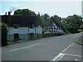
3
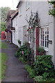
Cottages on Southam Road, Ladbroke
The first of this row of cottages is called the Old Post Office, presumably as a reminder of its old role; there are no shops of any sort in Ladbroke now although the village does still have a pub. The telephone box is no longer functional.
Image: © Stephen McKay
Taken: 1 Jul 2021
0.07 miles
4
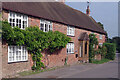
Village Farm, Ladbroke
A row of cottages on Southam Road in the centre of the village.
Image: © Stephen McKay
Taken: 1 Jul 2021
0.08 miles
5
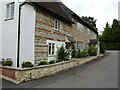
Cottage with tiers of stone
An unusual cottage in the village of Ladbroke with a front of different local stone. Lay in course there is local ironstone, lias and white lias stone in evidence.
Image: © Philip Halling
Taken: 13 Sep 2021
0.08 miles
6
Ladbroke
This large house, situated beside what used to be the main Southam-Banbury road before a bypass was built, has the appearance of once being a pub. This view is looking east at the bend as the road heads towards Southam to the north of the village.
Image: © David Stowell
Taken: 30 Mar 2006
0.10 miles
7
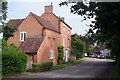
Southam Road, Ladbroke
Until the village was by-passed in 1985, this was part of the A423 between Southam and Banbury. The large house on the left, called 'High House', dates from the late 18th century and is grade II listed; the extension is a former coach house.
Image: © Stephen McKay
Taken: 1 Jul 2021
0.10 miles
8
Windmill Lane, Ladbroke
Cottages beside Windmill Lane. This length of Windmill lane has now been truncated by the bypass on the Banbury Road. The other part of the lane to the east is accessed directly from the bypass.
Image: © David Stowell
Taken: 30 Mar 2006
0.10 miles
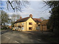
9
Ladbroke-The Bell Inn
Public House on Banbury Road
Image: © Ian Rob
Taken: 7 Aug 2009
0.10 miles
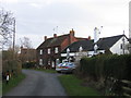
10
Ladbroke-Banbury Road
Cottages near the junction with Bridge Lane.
Image: © Ian Rob
Taken: 7 Aug 2009
0.10 miles