IMAGES TAKEN NEAR TO
Abbey Lane, SOUTHAM, CV47 1HR
Introduction
This page details the photographs taken nearby to Abbey Lane, CV47 1HR by members of the Geograph project.
The Geograph project started in 2005 with the aim of publishing, organising and preserving representative images for every square kilometre of Great Britain, Ireland and the Isle of Man.

There are currently over 7.5m images from over14,400 individuals and you can help contribute to the project by visiting https://www.geograph.org.uk
Image Map (Loading...)


Getting Data...Please wait
Leaflet Map data © OpenStreetMap
Images are licensed for reuse under creativecommons.org/licenses/by-sa/2.0
Notes
- Clicking on the map will re-center to the selected point.
- The higher the marker number, the further away the image location is from the centre of the postcode.
Image Listing (65 Images Found)
Images are licensed for reuse under creativecommons.org/licenses/by-sa/2.0
Image
Details
Distance
1
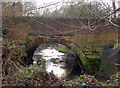
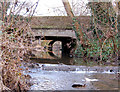
River Stowe, Browns Bridge, Southam (1)
Browns Bridge carries Banbury Road over the River Stowe in Southam, Warwickshire. This view shows the arch of the 1929-built bridge.
Image: © Andy F
Taken: 2 Jan 2009
0.08 miles
2
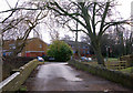
River Stowe, Browns Bridge, Southam (2)
Browns Bridge carries Banbury Road over the River Stowe in Southam, Warwickshire. This view shows the roadway over the old bridge. A new wider bridge was built in 1929 and is just visible to the right of this photo.
Image: © Andy F
Taken: 2 Jan 2009
0.09 miles
3
River Stowe, Browns Bridge, Southam (3)
Browns Bridge carries Banbury Road over the River Stowe in Southam, Warwickshire. This view shows the twin arches of the old bridge which was replaced in 1929.
Image: © Andy F
Taken: 2 Jan 2009
0.09 miles
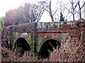
4
River Stowe, Browns Bridge, Southam (4)
Browns Bridge carries Banbury Road over the River Stowe in Southam, Warwickshire. This view shows the 1929-built bridge. The arch beyond is the old bridge it replaced.
Image: © Andy F
Taken: 2 Jan 2009
0.09 miles
7
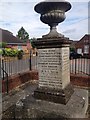
Memorial to the Dispensary
Dr. Henry Lilley-Smith (1787 - 1859), born in Southam, created the first self-supporting dispensary here which specialised in the treatment of diseases of the eyes and ears
The hospital, which was built on land owned by Dr Smith, contained about 14 beds and was supported by voluntary donations. The hospital treated about 12,220 patients during its first forty years, two thirds of whom were cured.
The Infirmary, which passed into the hands of trustees when Dr Smith died, continued for a few years but fell into financial difficulties and was forced to close in December 1872. Attempts were made to reinstate the hospital but financial constraints meant that none were successful.
In September 1889 a stone monument was presented to the Trustees to be placed at the site of the original Dispensary cottage with inscriptions detailing some of the charitable work Dr Smith encouraged including Allotments for Boys, the Maypole Holiday and the Dispensary itself.
Image: © Dave Thompson
Taken: 26 Jun 2015
0.13 miles
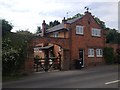
9
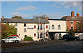
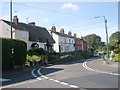
The Stoneythorpe Hotel, Warwick Road, Southam
Image: © Andy F
Taken: 23 Oct 2009
0.13 miles