IMAGES TAKEN NEAR TO
Marsh Road, STRATFORD-UPON-AVON, CV37 9XR
Introduction
This page details the photographs taken nearby to Marsh Road, CV37 9XR by members of the Geograph project.
The Geograph project started in 2005 with the aim of publishing, organising and preserving representative images for every square kilometre of Great Britain, Ireland and the Isle of Man.

There are currently over 7.5m images from over14,400 individuals and you can help contribute to the project by visiting https://www.geograph.org.uk
Image Map (Loading...)


Getting Data...Please wait
Leaflet Map data © OpenStreetMap
Images are licensed for reuse under creativecommons.org/licenses/by-sa/2.0
Notes
- Clicking on the map will re-center to the selected point.
- The higher the marker number, the further away the image location is from the centre of the postcode.
Image Listing (6 Images Found)
Images are licensed for reuse under creativecommons.org/licenses/by-sa/2.0
Image
Details
Distance
1
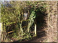
Narrow path to the lane
Wilmcote, path behind houses, parallel to village road.
Image: © Liz Stone
Taken: 2 Jan 2012
0.05 miles
2
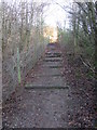
Footpath steps through the copse, Wilmcote
Image: © Liz Stone
Taken: 2 Jan 2012
0.09 miles
3
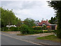
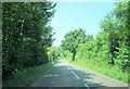
Houses at Wilmcote
These bungalows run along the south side of the road out of the village to the west towards Aston Holdings.
Image: © Nigel Mykura
Taken: 10 Jun 2011
0.13 miles
4
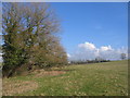
Footpath to Gipsy Hill Farm
Looking NE as the footpath follows the stream and hedge from the Aston Cantlow Road. The land rises to the right towards Wilmcote and further up the field a pair of hares were racing around.
Image: © David Stowell
Taken: 18 Feb 2006
0.15 miles
6
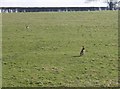
Hare today...
This pair of hares kept their distance as I walked along the footpath from the Aston Cantlow road to Gipsy Hill Farm, but otherwise didn't seem too concerned about my presence as they raced around the field.
Image: © David Stowell
Taken: 18 Feb 2006
0.16 miles