IMAGES TAKEN NEAR TO
Upper Quinton, STRATFORD-UPON-AVON, CV37 8LQ
Introduction
This page details the photographs taken nearby to CV37 8LQ by members of the Geograph project.
The Geograph project started in 2005 with the aim of publishing, organising and preserving representative images for every square kilometre of Great Britain, Ireland and the Isle of Man.

There are currently over 7.5m images from over14,400 individuals and you can help contribute to the project by visiting https://www.geograph.org.uk
Image Map
Images are licensed for reuse under creativecommons.org/licenses/by-sa/2.0
Notes
- Clicking on the map will re-center to the selected point.
- The higher the marker number, the further away the image location is from the centre of the postcode.
Image Listing (13 Images Found)
Images are licensed for reuse under creativecommons.org/licenses/by-sa/2.0
Image
Details
Distance
1
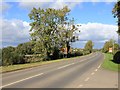
B4632 Stratford Road north of Lower Clopton
The Stratford Road as it leaves Lower Clopton heading north.
Image: © David P Howard
Taken: 12 Oct 2012
0.14 miles
2
![Lower Clopton Farm [1]](https://s3.geograph.org.uk/geophotos/02/79/40/2794075_3311bcc7_120x120.jpg)
Lower Clopton Farm [1]
The farm is seen, across the field, from the Heart of England Way. In the distance are the warehouses of Central Engineer Park, a government storage depot.
Image: © Michael Dibb
Taken: 4 Dec 2011
0.16 miles
3
![Lower Clopton Farm [3]](https://s1.geograph.org.uk/geophotos/03/11/21/3112197_d6e57cb5_120x120.jpg)
Lower Clopton Farm [3]
The farm is seen from Stratford Road (B4632). The farm offers a shop and a cafe.
Image: © Michael Dibb
Taken: 5 Aug 2012
0.16 miles
4
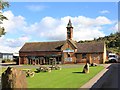
Lower Clopton Farm Shop
The farm shop http://www.lowerclopton.co.uk/ off the B4632 Stratford Road in Lower Clopton.
Image: © David P Howard
Taken: 12 Oct 2012
0.16 miles
5
![Lower Clopton Farm [2]](https://s3.geograph.org.uk/geophotos/02/79/41/2794111_d9e5164c_120x120.jpg)
Lower Clopton Farm [2]
The farm is seen, across the field, from the Heart of England Way. The Malvern Hills are in the far distance.
Image: © Michael Dibb
Taken: 4 Dec 2011
0.16 miles
6
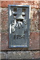
Benchmark on Lower Clopton Farm
Ordnance Survey flush bracket (serial number 1754) benchmark described on the Bench Mark Database at http://www.bench-marks.org.uk/bm10267
Image: © Roger Templeman
Taken: 27 Jun 2015
0.17 miles
7
![Lower Clopton Farm [4]](https://s0.geograph.org.uk/geophotos/03/11/22/3112216_01b00a69_120x120.jpg)
Lower Clopton Farm [4]
The farm is seen from Stratford Road (B4632), The farm offers a shop and a cafe. Meon Hill in the background.
Image: © Michael Dibb
Taken: 5 Aug 2012
0.17 miles
8
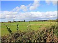
Fields near Clopton Orchard Farm
Looking NNW from the lay by on the B4632 Stratford Road, near Clopton Orchard Farm.
Image: © David P Howard
Taken: 12 Oct 2012
0.17 miles
9
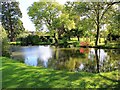
Pond on Lower Clopton Farm
View across the pond from the gateway on the B4632 Stratford Road.
Image: © David P Howard
Taken: 12 Oct 2012
0.19 miles
10
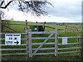
Farm facilities
A number of permissive ways have been created on the lower slopes of Meon Hill on land belonging to Lower Clopton Farm. At this focal point, there is a map of the new footpaths see Image, recycling bins and a sign indicating the facilities available at the farm.
Image: © Michael Dibb
Taken: 4 Dec 2011
0.20 miles