IMAGES TAKEN NEAR TO
Clifford Chambers, STRATFORD-UPON-AVON, CV37 8LF
Introduction
This page details the photographs taken nearby to CV37 8LF by members of the Geograph project.
The Geograph project started in 2005 with the aim of publishing, organising and preserving representative images for every square kilometre of Great Britain, Ireland and the Isle of Man.

There are currently over 7.5m images from over14,400 individuals and you can help contribute to the project by visiting https://www.geograph.org.uk
Image Map
Images are licensed for reuse under creativecommons.org/licenses/by-sa/2.0
Notes
- Clicking on the map will re-center to the selected point.
- The higher the marker number, the further away the image location is from the centre of the postcode.
Image Listing (2 Images Found)
Images are licensed for reuse under creativecommons.org/licenses/by-sa/2.0
Image
Details
Distance
1
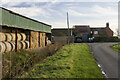
Little Willicote Farm
Traditional and modern farm buildings at Little Willicote Farm
Image: © P Gaskell
Taken: Unknown
0.01 miles
2
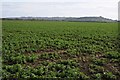
Field of broad beans
Field of broad beans in a field to the north of Lower Quinton. Ilmington Down, on the left, and Meon Hill on the right can be seen in the background, hills which are part of the Cotswold Hills but both are unusual in that they are in Warwickshire. Ilmington Down is the highest point in Warwickshire.
Image: © Philip Halling
Taken: 25 Mar 2016
0.18 miles