IMAGES TAKEN NEAR TO
Milcote, STRATFORD-UPON-AVON, CV37 8AB
Introduction
This page details the photographs taken nearby to CV37 8AB by members of the Geograph project.
The Geograph project started in 2005 with the aim of publishing, organising and preserving representative images for every square kilometre of Great Britain, Ireland and the Isle of Man.

There are currently over 7.5m images from over14,400 individuals and you can help contribute to the project by visiting https://www.geograph.org.uk
Image Map
Images are licensed for reuse under creativecommons.org/licenses/by-sa/2.0
Notes
- Clicking on the map will re-center to the selected point.
- The higher the marker number, the further away the image location is from the centre of the postcode.
Image Listing (13 Images Found)
Images are licensed for reuse under creativecommons.org/licenses/by-sa/2.0
Image
Details
Distance
1
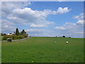
Fields near Milcote Castle
The road on the left is Milcote Road, the minor road leading from Clifford Chambers to Welford. The castle, of which no remains are left visible, is believed to have stood in the field on the other side of the road. It was once the home of the Greville Family and the large house visible in the trees on the left of the photo is called Greville Mount.
Image: © Nigel Mykura
Taken: 16 Apr 2012
0.09 miles
2
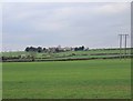
View towards Clifford Hill Farm
View NNW from the minor lane off the B4632, right across the gridsquare, towards Clifford Hill Farm on the northern edge.
Image: © David P Howard
Taken: 1 Apr 2011
0.19 miles
3
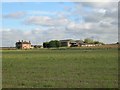
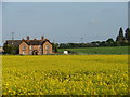
Burnthouse Cottages and Barn from The Greenway
Looking ENE from The Greenway foot and cycle path towards Burnthouse Cottages on the left and Burnthouse Barn on the right.
Image: © David P Howard
Taken: 24 Oct 2010
0.19 miles
4
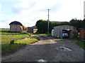
Burnthouse Barn
The original dutch barn and some modern barns are seen from the bridleway.
Image: © Michael Dibb
Taken: 6 Nov 2011
0.21 miles
5
Burnthouse Barn and Yellow Field
Taken from The Greenway long distance path.
Image: © Ian Paterson
Taken: 13 May 2008
0.21 miles
6
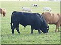
He is magnificent
This magnificent bull is seen from the bridleway.
Image: © Michael Dibb
Taken: 6 Nov 2011
0.22 miles
7
![Burnthouse Barn and Cottages [2]](https://s3.geograph.org.uk/geophotos/02/77/70/2777031_21dca366_120x120.jpg)
Burnthouse Barn and Cottages [2]
The barn and the cottages are seen from the bridleway.
Image: © Michael Dibb
Taken: 6 Nov 2011
0.22 miles
8
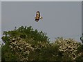
On the Wing
Buzzard flying off to his perch.
Image: © Ian Paterson
Taken: 13 May 2008
0.22 miles
9
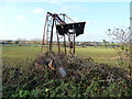
Pump no more
This broken elderly wind pump alongside the bridleway will pump no more.
Image: © Michael Dibb
Taken: 6 Nov 2011
0.24 miles
10
![Burnthouse Cottages and Barn [1]](https://s1.geograph.org.uk/geophotos/02/77/67/2776765_f40d7bfe_120x120.jpg)
Burnthouse Cottages and Barn [1]
The cottages and barn are seen, across the field, from The Greenway a footpath and bicycle track along the line of the dismantled Great Western Railway. The Greenway is part of the Monarch's Way long distance path.
Image: © Michael Dibb
Taken: 6 Nov 2011
0.24 miles