IMAGES TAKEN NEAR TO
Coleridge Close, STRATFORD-UPON-AVON, CV37 7HF
Introduction
This page details the photographs taken nearby to Coleridge Close, CV37 7HF by members of the Geograph project.
The Geograph project started in 2005 with the aim of publishing, organising and preserving representative images for every square kilometre of Great Britain, Ireland and the Isle of Man.

There are currently over 7.5m images from over14,400 individuals and you can help contribute to the project by visiting https://www.geograph.org.uk
Image Map
Images are licensed for reuse under creativecommons.org/licenses/by-sa/2.0
Notes
- Clicking on the map will re-center to the selected point.
- The higher the marker number, the further away the image location is from the centre of the postcode.
Image Listing (26 Images Found)
Images are licensed for reuse under creativecommons.org/licenses/by-sa/2.0
Image
Details
Distance
1
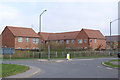
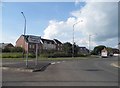
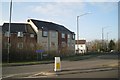
Bland
Some of the typically bland, identikit new housing being built on the outskirts of Stratford upon Avon. This historic area has been identified as a housing growth area and unfortunately the architecture is often of this standard.
Image: © Colin Craig
Taken: 2 Apr 2009
0.00 miles
2
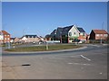
Budgens of Trinity Mead
View NE towards the Budgens store next to a roundabout on the A4390 on the outskirts of Stratford Upon Avon.
Image: © David P Howard
Taken: 7 Mar 2010
0.03 miles
3
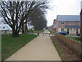
Footpath to the White House
This is a view SW along the footpath from the Banbury Road. This area was formerly Bridgetown Farm however it has recently been developed into a housing estate which has retained the name of Bridgetown. In the middle of this development sat the White House.
Image: © David Stowell
Taken: 5 Feb 2006
0.03 miles
4
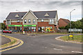
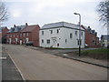
The Co-operative Food
This store used to be a Budgens, see earlier photo Image
Image: © David P Howard
Taken: 29 Jul 2016
0.03 miles
5
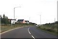
Roundabout on the A4390, Stratford on Avon
The small bypass appears very recent. No material is easy to find online but I certainly don't remember it being there in the past, plus the houses are all newly built as well.
Image: © David Howard
Taken: 3 Jun 2018
0.05 miles
7
Long Fellow Road, Bridgetown
Looking SW into the new housing estate development on the site of Bridgetown Farm.
Image: © David Stowell
Taken: 5 Feb 2006
0.11 miles
8
The roofs of Trinity Way
Recent development on the shoulder of Alveston Hill hits the skyline. On the right the A422 Banbury Road heads for Stratford while the A4390 to the left is the start of a southern relief road.
Image: © Robin Stott
Taken: 6 Mar 2011
0.14 miles
9
New apartments, top of Trinity Way
Facing the junction with the 422 Banbury Road.
Image: © Robin Stott
Taken: 6 Mar 2011
0.14 miles
10
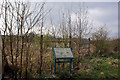
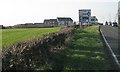
Protecting the wild
Behind the fence and display board is a new woodland and meadowland area being developed by the local authorities in the Bridgetown area of Stratford upon Avon. Native trees and plants were planted in 2003 and the area has been fenced off to allow them to establish. Eventually it will be a park area.
Image: © Colin Craig
Taken: 2 Apr 2009
0.18 miles