IMAGES TAKEN NEAR TO
Cowslip Road, STRATFORD-UPON-AVON, CV37 7EG
Introduction
This page details the photographs taken nearby to Cowslip Road, CV37 7EG by members of the Geograph project.
The Geograph project started in 2005 with the aim of publishing, organising and preserving representative images for every square kilometre of Great Britain, Ireland and the Isle of Man.

There are currently over 7.5m images from over14,400 individuals and you can help contribute to the project by visiting https://www.geograph.org.uk
Image Map
Images are licensed for reuse under creativecommons.org/licenses/by-sa/2.0
Notes
- Clicking on the map will re-center to the selected point.
- The higher the marker number, the further away the image location is from the centre of the postcode.
Image Listing (19 Images Found)
Images are licensed for reuse under creativecommons.org/licenses/by-sa/2.0
Image
Details
Distance
1
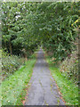
The Old Tramway
Route of the old horse drawn tramway from Stratford upon Avon to Moreton in Marsh and Shipston on Stour. This is now a foot and cycle path. For further information on the tramway see Image
Image: © David P Howard
Taken: 12 Oct 2013
0.09 miles
2
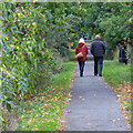
The Old Tramway
Route of the old horse drawn tramway from Stratford upon Avon to Moreton in Marsh and Shipston on Stour. This is now a foot and cycle path. For further information on the tramway see Image
Image: © David P Howard
Taken: 12 Oct 2013
0.13 miles
3
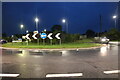
Roundabout on Shipton Road, Stratford-upon-Avon
Image: © David Howard
Taken: 29 Aug 2023
0.16 miles
4
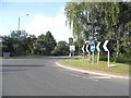
Roundabout on Trinity Way, Stratford on Avon
Image: © David Howard
Taken: 3 Jun 2018
0.16 miles
5

The Old Tramway
Looking south along the old tramway as it crosses the bridge over the cycleway and footpath into the Recreation Ground.
For more information on the tramway see Image
Image: © David P Howard
Taken: 12 Oct 2013
0.16 miles
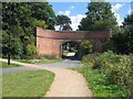
6
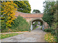
Tramway Bridge
This bridge used to carry the horse drawn tramway from Stratford upon Avon to Moreton in Marsh and Shipston on Stour. For a photo from August 2005 and additional information see Image
Image: © David P Howard
Taken: 12 Oct 2013
0.16 miles
7
Shipston Road
The A3400 Shipston Road entering Stratford-upon-Avon.
There are many B&B guest houses along this and other entry roads into the town.
Image: © David P Howard
Taken: 12 Oct 2013
0.17 miles
8
Tramway Bridge
This bridge used to carry the horse drawn tramway from Stratford upon Avon to Moreton in Marsh and Shipston on Stour. The GWR converted the Moreton in Marsh to Shipston on Stour sections into a "conventional" steam railway by 1889. Occasional horse drawn traffic, mainly for the carriage of lime, continued on this length from Longdon Road to Stratford upon Avon; however the line gradually became derelict. It was briefly cleared and inspected in 1904 with a view to refurbishment; however, the rails were finally lifted in 1918 to provide scrap for the war effort. The Longdon Road - Stratford upon Avon section was finally formally abandoned in the GWR Act of 1926, exactly 100 years after the line opened.
The line ran mainly beside the road and through open countryside and most of the route can still be followed today. As well as the tramway bridge in Stratford Image and roadside sections such as Image there are locations where the original stone block "sleepers" can still be seen Image
Image: © David Stowell
Taken: 7 Aug 2005
0.17 miles
9
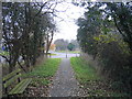
Course of Stratford and Moreton Tramway
The course of the tramway has been converted into a public footpath along this stretch. It is now crossed by the new Stratford southern bypass, itself built on the formation of the former Stratford-upon-Avon and Midland Junction Railway to the Northampton area.
Image: © David Stowell
Taken: 13 Dec 2005
0.18 miles
10

Rosebird Community Hall
Opened on Saturday 1st September 2012. http://www.rosebirdcommunityhall.org/
Image: © David P Howard
Taken: 29 Jul 2016
0.19 miles