IMAGES TAKEN NEAR TO
New Street, STRATFORD-UPON-AVON, CV37 6EB
Introduction
This page details the photographs taken nearby to New Street, CV37 6EB by members of the Geograph project.
The Geograph project started in 2005 with the aim of publishing, organising and preserving representative images for every square kilometre of Great Britain, Ireland and the Isle of Man.

There are currently over 7.5m images from over14,400 individuals and you can help contribute to the project by visiting https://www.geograph.org.uk
Image Map
Images are licensed for reuse under creativecommons.org/licenses/by-sa/2.0
Notes
- Clicking on the map will re-center to the selected point.
- The higher the marker number, the further away the image location is from the centre of the postcode.
Image Listing (475 Images Found)
Images are licensed for reuse under creativecommons.org/licenses/by-sa/2.0
Image
Details
Distance
1
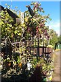
Grape Crop Stratford on Avon
Good crop of grapes growing outside, Saffron Meadow Stratford on Avon
Image: © Roy Hughes
Taken: 7 Oct 2014
0.06 miles
2
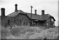
The LMS Station, road side, Stratford-upon-Avon
The LMS Station at Stratford was the only station of any importance on the Stratford-upon-Avon & Midland Junction Railway - a rural trailway that meandered across the southern midlands from Ravenstone Wood Junc (near Bedford) in the east, to Broom Junc (near Alcester) in the west.
Withdrawal of the passenger service inevitably came early; that to the west of Stratford ended in May 1949, & that to the east in April 1952. It remained open as a through route for goods trains (notably ore trains from Northamptonshire to South Wales) until 1960. West of Stratford then closed completely, but a goods service to Stratford from the east lasted until 1965. The notice at the far gable suggests the building is up for sale. All has gone now though & the trackbed has been used for the A4390. For a view of the rail-side elevation see: Image
Image: © Martin Tester
Taken: Unknown
0.07 miles
3
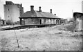
The LMS Station, rail side, Stratford-upon-Avon
The LMS Station at Stratford was the only station of any importance on the Stratford-upon-Avon & Midland Junction Railway - a rural trailway that meandered across the southern midlands from Ravenstone Wood Junc (near Bedford) in the east, to Broom Junc (near Alcester) in the west. The view here is towards the east.
Withdrawal of the passenger service inevitably came early; that to the west of Stratford ended in May 1949, & that to the east in April 1952. It remained open as a through route for goods trains (notably ore trains from Northamptonshire to South Wales) until 1960. West of Stratford then closed completely, but a goods service to Stratford from the east lasted until 1965. All has gone now & the trackbed has been used for the A4390. For a view of the road-side elevation see: Image
Image: © Martin Tester
Taken: Unknown
0.07 miles
4
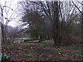
Railway relic
Now between Seven Meadows Road (A4390) and a footpath, this is a reminder of the former railway lines, which crossed here and served Stratford's second station. Goods would also have been transferred to and from the river at a wharf near Lucy's Mill. There was an agricultural merchant business nearby until the 1980s, named after the local Lucy family.
Image: © Liz Stone
Taken: 7 Jan 2013
0.08 miles
5
Stratford-upon-Avon Old Town railway station (site), Warwickshire
Opened in 1873 by the Stratford-upon-Avon & Midland Junction Railway on the line from Stratford to Towcester, this station closed to passengers in 1952 and completely in 1965.
View east towards Ettington and Towcester. No trace remains.
Image: © Nigel Thompson
Taken: 19 Jun 2019
0.08 miles
7
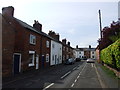
Ryland Street
Looking east towards the river.
Image: © Alan Murray-Rust
Taken: 6 Mar 2011
0.09 miles
8
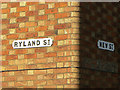
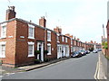
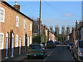
Ryland St and New St
A detail showing the typical brickwork in the Old Town district - Flemish bond with paler headers giving a chequer pattern to the brickwork, and the corner of the building finished with bull-nose bricks to give a soft corner to the building. A nice pair of cast iron street names rounds off the picture.
Image: © Alan Murray-Rust
Taken: 6 Mar 2011
0.09 miles
9
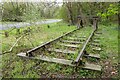
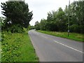
Track on the site of a former station
This railway track is beside Stratford-upon-Avon's bypass. This was the site of the former railway line which linked the town with Northamptonshire.
Image: © Philip Halling
Taken: 6 Apr 2022
0.09 miles