IMAGES TAKEN NEAR TO
Barley Close, Church Lane, STRATFORD-UPON-AVON, CV37 0LQ
Introduction
This page details the photographs taken nearby to Barley Close, Church Lane, CV37 0LQ by members of the Geograph project.
The Geograph project started in 2005 with the aim of publishing, organising and preserving representative images for every square kilometre of Great Britain, Ireland and the Isle of Man.

There are currently over 7.5m images from over14,400 individuals and you can help contribute to the project by visiting https://www.geograph.org.uk
Image Map (Loading...)


Getting Data...Please wait
Leaflet Map data © OpenStreetMap
Images are licensed for reuse under creativecommons.org/licenses/by-sa/2.0
Notes
- Clicking on the map will re-center to the selected point.
- The higher the marker number, the further away the image location is from the centre of the postcode.
Image Listing (140 Images Found)
Images are licensed for reuse under creativecommons.org/licenses/by-sa/2.0
Image
Details
Distance
1
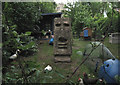
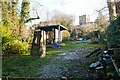
Private garden, Snitterfield
A clearer, sunnier view is Image
Image: © Robin Stott
Taken: 21 Jul 2010
0.01 miles
2
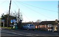
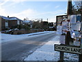
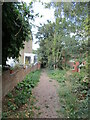
Church Lane Snitterfield
A small cul-de-sac lane on the northern edge of the village opposite the village church.The street sign sports the local parish notice board.
Image: © Nigel Mykura
Taken: 9 Jan 2011
0.05 miles
3
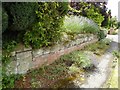
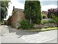
Surviving wall from grounds of Snitterfield House
A red-brick garden wall on foundations of ashlar stone. This wall is Grade II listed and is part of the grounds of Snitterfield House, a late 17th century house which was demolished in the early 19th century. The house was home to the 1st and 2nd Earls of Coventry, the family seat being Croome Court in Worcestershire.
Historic England description
Wall, part of that to grounds of Snitterfield House (late C17 house demolished in early C19). Late C17. Brick with ashlar dressings. Ashlar plinth, quoins to angle and gabled ashlar coping. Wall ends at south-east end in brick pier; at north-west end it has short return to front of Tall Wall, now sloping down to plinth. Some C18 repairs. The wall is opposite the west end of the Church of St James, and is included for group value. (Buildings of England: Pevsner N: Warwickshire: Harmondsworth: 1966-: 399).
Source: https://www.historicengland.org.uk/listing/the-list/list-entry/1382180
Image: © Philip Halling
Taken: 5 Aug 2016
0.05 miles
5
Easter Island in Snitterfield
One house owner in Snitterfield has added a touch of the exotic to their garden.
Image: © Colin Craig
Taken: 25 Dec 2009
0.06 miles
6
Footpath off Church Road, Snitterfield
Image: © Jonathan Thacker
Taken: 20 Sep 2021
0.06 miles
7
Wall opposite Snitterfield church
A red-brick garden wall on foundations of ashlar stone. This wall is Grade II listed and is part of the grounds of Snitterfield House, a late 17th century house which was demolished in the early 19th century. The house was home to the 1st and 2nd Earls of Coventry, the family seat being Croome Court in Worcestershire.
Historic England description
Wall, part of that to grounds of Snitterfield House (late C17 house demolished in early C19). Late C17. Brick with ashlar dressings. Ashlar plinth, quoins to angle and gabled ashlar coping. Wall ends at south-east end in brick pier; at north-west end it has short return to front of Tall Wall, now sloping down to plinth. Some C18 repairs. The wall is opposite the west end of the Church of St James, and is included for group value. (Buildings of England: Pevsner N: Warwickshire: Harmondsworth: 1966-: 399).
Source: https://www.historicengland.org.uk/listing/the-list/list-entry/1382180
Image: © Philip Halling
Taken: 5 Aug 2016
0.06 miles
8

Wall, part of the grounds to Snitterfield House
A red-brick garden wall on foundations of ashlar stone. This wall is Grade II listed and is part of the grounds of Snitterfield House, a late 17th century house which was demolished in the early 19th century. The house was home to the 1st and 2nd Earls of Coventry, the family seat being Croome Court in Worcestershire.
Historic England description
Wall, part of that to grounds of Snitterfield House (late C17 house demolished in early C19). Late C17. Brick with ashlar dressings. Ashlar plinth, quoins to angle and gabled ashlar coping. Wall ends at south-east end in brick pier; at north-west end it has short return to front of Tall Wall, now sloping down to plinth. Some C18 repairs. The wall is opposite the west end of the Church of St James, and is included for group value. (Buildings of England: Pevsner N: Warwickshire: Harmondsworth: 1966-: 399).
Source: https://www.historicengland.org.uk/listing/the-list/list-entry/1382180
Image: © Philip Halling
Taken: 5 Aug 2016
0.06 miles
9
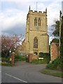
Snitterfield
The expansively named St James the Great Church.
Image: © David Stowell
Taken: 11 Apr 2005
0.06 miles
10
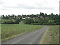
Snitterfield from below Lodge Farm
The north end of this large village.The Bell Brook crosses the picture, right to left. The church tower shows from behind the tree, upper right. Foreground: part of an extensive field of beans.
Image: © Robin Stott
Taken: 21 Jul 2010
0.06 miles