IMAGES TAKEN NEAR TO
Wolverton Road, STRATFORD-UPON-AVON, CV37 0HB
Introduction
This page details the photographs taken nearby to Wolverton Road, CV37 0HB by members of the Geograph project.
The Geograph project started in 2005 with the aim of publishing, organising and preserving representative images for every square kilometre of Great Britain, Ireland and the Isle of Man.

There are currently over 7.5m images from over14,400 individuals and you can help contribute to the project by visiting https://www.geograph.org.uk
Image Map (Loading...)


Getting Data...Please wait
Leaflet Map data © OpenStreetMap
Images are licensed for reuse under creativecommons.org/licenses/by-sa/2.0
Notes
- Clicking on the map will re-center to the selected point.
- The higher the marker number, the further away the image location is from the centre of the postcode.
Image Listing (13 Images Found)
Images are licensed for reuse under creativecommons.org/licenses/by-sa/2.0
Image
Details
Distance
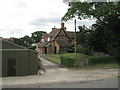
2
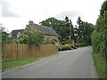
Glebe Farm and Pear Tree Cottage
The buildings lie to the east of the Wolverton Road, behind the hedge. White van passing. The cottage is the new house on the right. On the skyline, left, is Norton Lindsey.
Image: © Robin Stott
Taken: 3 Feb 2011
0.06 miles
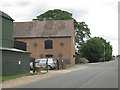
4
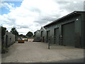
Sheds, Glebe Farm
From signs and vehicles it might be deduced that some or all of Glebe Farm is occupied by small businesses, one of which is Avon Country Storage.
Image: © Robin Stott
Taken: 21 Jul 2010
0.10 miles
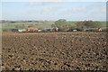
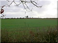
5
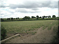
Fields north of Glebe Farm
The view shows how the land falls away to the north of the ridge north of Snitterfield, towards the marshy ground in Image
Image: © Robin Stott
Taken: 21 Jul 2010
0.13 miles
6
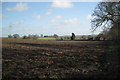
Field south of Glebe Farm
Looking towards Lodge Farm; Holly Cottage on the right, by the Wolverton Road.
Image: © Robin Stott
Taken: 3 Feb 2011
0.14 miles
7
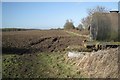
View past a tank above Glebe Farm
Snitterfield Bushes and Glebe Wood on the left are examples of the hilltop woodlands in the area. The footpath by the hedge, route of Monarch's Way, follows the ridge before descending to Langley. On the other side of the hedge is a gentle northeast-facing scarp.
Image: © Robin Stott
Taken: 3 Feb 2011
0.17 miles
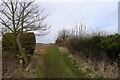
9
Monarch's Way near Snitterfield
This long distance footpath runs along the crest of a low ridge following a hedgerow which can be seen in the distance.
Image: © Nigel Mykura
Taken: 22 Jan 2012
0.18 miles
10
The Monarch's Way heading north from Snitterfield
Image: © Tim Heaton
Taken: 13 Apr 2013
0.20 miles