IMAGES TAKEN NEAR TO
Birmingham Road, STRATFORD-UPON-AVON, CV37 0ET
Introduction
This page details the photographs taken nearby to Birmingham Road, CV37 0ET by members of the Geograph project.
The Geograph project started in 2005 with the aim of publishing, organising and preserving representative images for every square kilometre of Great Britain, Ireland and the Isle of Man.

There are currently over 7.5m images from over14,400 individuals and you can help contribute to the project by visiting https://www.geograph.org.uk
Image Map
Images are licensed for reuse under creativecommons.org/licenses/by-sa/2.0
Notes
- Clicking on the map will re-center to the selected point.
- The higher the marker number, the further away the image location is from the centre of the postcode.
Image Listing (5 Images Found)
Images are licensed for reuse under creativecommons.org/licenses/by-sa/2.0
Image
Details
Distance
1
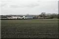
College Farm southeast of Bearley
Seen from the bridleway that is a continuation of Ash Lane. The light-coloured pattern is a barn under construction. The A3400 runs behind the hedge. The bump on the skyline is probably Bannam's Wood southeast of Morton Bagot in SP1164.
Image: © Robin Stott
Taken: 3 Feb 2011
0.02 miles
2
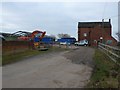
College Farm
This site is being developed and has several cottages and a B1 industrial unit planned. Construction was well under way.
Image: © Nigel Mykura
Taken: 29 Jan 2011
0.04 miles
3
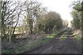
Track to College Farm
Turning northwest off Ash Lane south of Bearley. It's also a footpath and bridleway.
Image: © Robin Stott
Taken: 3 Feb 2011
0.20 miles
4
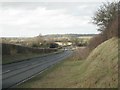
A3400 southwest of Bearley
Heading for Bearley Cross and Wotton Wawen. Austey Wood on the skyline in Image
Image: © Robin Stott
Taken: 3 Feb 2011
0.21 miles
5
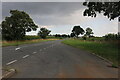
Parking area on Birmingham Road, Bearley
Image: © David Howard
Taken: 8 Aug 2021
0.24 miles