IMAGES TAKEN NEAR TO
Lonscale Drive, COVENTRY, CV3 6QR
Introduction
This page details the photographs taken nearby to Lonscale Drive, CV3 6QR by members of the Geograph project.
The Geograph project started in 2005 with the aim of publishing, organising and preserving representative images for every square kilometre of Great Britain, Ireland and the Isle of Man.

There are currently over 7.5m images from over14,400 individuals and you can help contribute to the project by visiting https://www.geograph.org.uk
Image Map
Images are licensed for reuse under creativecommons.org/licenses/by-sa/2.0
Notes
- Clicking on the map will re-center to the selected point.
- The higher the marker number, the further away the image location is from the centre of the postcode.
Image Listing (34 Images Found)
Images are licensed for reuse under creativecommons.org/licenses/by-sa/2.0
Image
Details
Distance
1
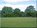
Green space off Kenpas Highway
This is the area marked as a moat on the OS map and is adjacent to Stivichall Grange which is hidden by the trees.
Image: © E Gammie
Taken: 7 May 2020
0.02 miles
2
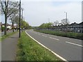
A45, Kenpas Highway
Although it looks empty of traffic, there are a few vehicles approaching from the Leamington Road roundabout and others about to pass the photographer's position. However, it's quite sparse for 3:30pm on a Thursday afternoon. The prevailing Coronavirus (COVID-19) pandemic 'lockdown' conditions have noticeably reduced traffic density.
Image: © E Gammie
Taken: 16 Apr 2020
0.05 miles
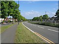
3
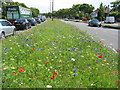
A45 Kenpas Highway
The central reservation of the dual carriageway between Bathway Road and the Leamington Road roundabout, showing the colourful result of a springtime sowing of mixed flower seed by the council. The mix includes cornflowers, poppies, fairy toadflax, larkspur, cosmos and marigolds amongst others.
Image: © E Gammie
Taken: 10 Jul 2014
0.06 miles
4
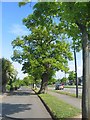
Oak, Kenpas Highway
The oak stands out from the other trees lining the Highway which are largely some type of maple. From the trunk's girth it would seem to predate the construction of the southern bypass road in the 1930s - nice that its presence was respected.
The road on the left is a service road for the houses along the highway.
Image: © E Gammie
Taken: 7 May 2020
0.08 miles
5
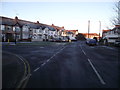
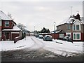
A frosty city morning
Inter war years housing on the junction of Erithway and Anchorway Roads.
Image: © Anthony Vosper
Taken: 6 Dec 2014
0.13 miles
6
A45, Kenpas Highway
An empty looking carriageway at 4:40pm on a Thursday afternoon. Actually, there is a fair amount of traffic but much reduced during the Covid-19 pandemic 'lockdown'.
Image: © E Gammie
Taken: 7 May 2020
0.14 miles
8
Kenpas Highway
The A45 in the southern suburbs of Coventry.
Image: © E Gammie
Taken: 29 Oct 2007
0.16 miles
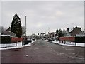
9
Road leading to Poolside Gardens
The road that leads to Poolside Gardens, A residential dead-end road that is built on the site of Kenpas Swimming Pool that closed in the 1960's.
Image: © James Cobbett
Taken: 7 Jan 2010
0.16 miles
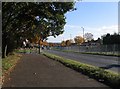
10
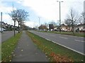
Kenpas Highway, Coventry
The Kenpas Highway section of the A45, running between the Leamington Road roundabout and Kenilworth Road crossroads. Part of the Coventry southern bypass constructed in the 1930s. To the left is the service road for houses facing the highway.
This photo replicates that taken in 2005 by David Stowell (Image), the only noticeable difference being the lamp standards.
Image: © E Gammie
Taken: 6 Nov 2020
0.16 miles