IMAGES TAKEN NEAR TO
Mantilla Drive, COVENTRY, CV3 6PW
Introduction
This page details the photographs taken nearby to Mantilla Drive, CV3 6PW by members of the Geograph project.
The Geograph project started in 2005 with the aim of publishing, organising and preserving representative images for every square kilometre of Great Britain, Ireland and the Isle of Man.

There are currently over 7.5m images from over14,400 individuals and you can help contribute to the project by visiting https://www.geograph.org.uk
Image Map
Images are licensed for reuse under creativecommons.org/licenses/by-sa/2.0
Notes
- Clicking on the map will re-center to the selected point.
- The higher the marker number, the further away the image location is from the centre of the postcode.
Image Listing (83 Images Found)
Images are licensed for reuse under creativecommons.org/licenses/by-sa/2.0
Image
Details
Distance
1
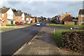
North on Mantilla Drive at the Dewsbury Avenue turn
Image: © Robin Stott
Taken: 4 Dec 2012
0.02 miles
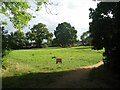
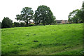
2
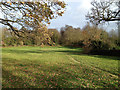
Chideock Hill open space, formerly Stivichall village green
Preserved, as I understand it, through purchase by Coventry Corporation from the Gregory family in 1929, because of the threat of development by them of a much enjoyed spot, Stivichall Hamlet.
Image: © Robin Stott
Taken: 4 Dec 2012
0.06 miles
3
Easedale Close
A cul-de-sac leading to Chideock Hill open space.
Image: © Robin Stott
Taken: 4 Dec 2012
0.06 miles
4
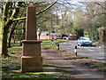
Monument near Coat of Arms bridge
The inscription on the monument is on the side facing the road, and reads:
"This green with the adjoining hamlet of Stivichall was presented to the City of Coventry in 1932 by Major Charles Hugh Gregory-Hood in memory of the Gregory family, who were owners of the manor of Stivichall for over 400 years."
Image: © Keith Williams
Taken: 3 Mar 2007
0.07 miles
5
Green by Stivichall Croft
A public green between Chideock Hill and Stivichall Croft. The notice in the foreground reads: "Strictly no BBQ's at any time". It may be a permanent restriction or related to the long period of dry weather experienced in July and August 2022 and the consequent risk of fire.
Image: © E Gammie
Taken: 15 Sep 2022
0.07 miles
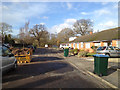
6
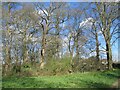
Near Baginton Road
A small area of woodland between Stivichall Croft and Baginton Road.
Image: © E Gammie
Taken: 5 Apr 2021
0.07 miles
7
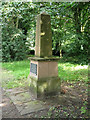
The Gregory obelisk, Stivichall Croft, Coventry CV3
The inscription reads: This green / with the adjoining hamlet of Stivichall / was presented to the City of Coventry / in 1932 / by Major Charles Hugh Gregory-Hood / in memory of the Gregory family / who were owners of the Manor of / Stivichall / for over 400 years
In the 1920s Coventry was expanding fast as a manufacturing centre but the picturesque hamlet of Stivichall somehow survived 20th-century intrusions. There was widespread regret when the Gregory family started building houses on their land in 1928. To preserve this relic of bygone Warwickshire the Corporation bought nine and a half acres and the Major, with some encouragement, gave a further one and a quarter acres – on condition that the gift was marked by a stone. It was erected in the winter of 1932-33, of pink sandstone, at a cost of about £88. See also Image and Image
Shortly afterwards an almost identical obelisk was erected to the memory of the Conservators of the Stoke Commons, by the Binley Road in Image
Image: © Robin Stott
Taken: 9 Aug 2012
0.08 miles
8
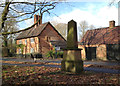
The Gregory obelisk, blacksmith's house and forge, Stivichall Croft
The inscription (facing the road) reads: This green / with the adjoining hamlet of Stivichall / was presented to the City of Coventry / in 1932 / by Major Charles Hugh Gregory-Hood / in memory of the Gregory family / who were owners of the Manor of / Stivichall / for over 400 years
In the 1920s Coventry was expanding fast as a manufacturing centre but the picturesque hamlet of Stivichall somehow survived 20th-century intrusions. This view shows the former blacksmith's house, left, and the former forge, right. Coventry History Centre has a photo of a horse being led to the forge to be shod.
There was widespread regret when the Gregory family started building houses on their land in 1928. To preserve this relic of bygone Warwickshire the Corporation bought nine and a half acres and the Major, with some encouragement, gave a further one and a quarter acres – on condition that the gift was marked by a stone. It was erected in the winter of 1932-33, of pink sandstone, at a cost of about £88. See also SP3276 : Monument near Coat of Arms bridge and SP3276 : Coat of Arms Bridge Road. Shortly afterwards an almost identical obelisk was erected to the memory of the Conservators of the Stoke Commons, by the Binley Road in SP3578: Image
This photo appears in a forthcoming book about Warwickshire's obelisks by the Warwickshire Gardens Trust.
Image: © Robin Stott
Taken: 4 Dec 2012
0.08 miles
9
Chideock Hill open space, Coventry CV3
Once, this was the village green of Stivichall hamlet, a picturesque relic of bygone Warwickshire. It was bought by the Corporation in 1932 to save it from being built on by the owners, the Gregory family; see Image
Image: © Robin Stott
Taken: 9 Aug 2012
0.08 miles
10
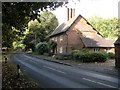
Coventry-Stivichall Croft
Looking towards the Coat of Arms bridge. A leafy lane not far from the City Centre.
Image: © Ian Rob
Taken: 10 Oct 2009
0.08 miles