IMAGES TAKEN NEAR TO
Humphrey Burton Road, COVENTRY, CV3 6HX
Introduction
This page details the photographs taken nearby to Humphrey Burton Road, CV3 6HX by members of the Geograph project.
The Geograph project started in 2005 with the aim of publishing, organising and preserving representative images for every square kilometre of Great Britain, Ireland and the Isle of Man.

There are currently over 7.5m images from over14,400 individuals and you can help contribute to the project by visiting https://www.geograph.org.uk
Image Map
Images are licensed for reuse under creativecommons.org/licenses/by-sa/2.0
Notes
- Clicking on the map will re-center to the selected point.
- The higher the marker number, the further away the image location is from the centre of the postcode.
Image Listing (115 Images Found)
Images are licensed for reuse under creativecommons.org/licenses/by-sa/2.0
Image
Details
Distance
3
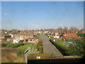
Northwest on The Hiron, Coventry
The ground at lower right is part of an allotment site. The view is from a Coventry-Leamington Spa train.
Image: © Robin Stott
Taken: 8 Nov 2021
0.07 miles
4
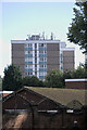
Kenilworth Court
The end of a 1960s apartment block, its roof scattered with cellular antennae.
Image: © Bob Harvey
Taken: 5 Oct 2021
0.11 miles
5
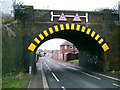
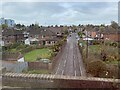
The Hiron Rail Bridge
A double decker bus tried to fit through this rail bridge but failed! - therefore it has been painted recently in vibrant yellow/black colours.
Image: © John Curran
Taken: 13 Feb 2006
0.11 miles
6
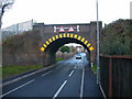
Coventry-The Hiron Bridge
Carrying the Line to Leamington.
Image: © Ian Rob
Taken: 14 Nov 2007
0.11 miles
7
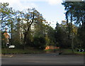
Kenilworth Court
Mature trees disguise the bulk of the 11-storey Kenilworth Court flats, built in 1960-61 (architect G. R. Stone) - the building is more dominant from other directions ( Image] ). In the foreground, Warwick Road (left) splits to become Leamington Road (ahead) and Kenilworth Road (right).
Image: © E Gammie
Taken: 9 Nov 2014
0.11 miles
8
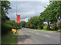
Leamington Road
Near the north-eastern entrance to the Memorial Park. The c. 1960 Kenilworth Court block of flats stands near the Warwick Road junction.
The banners on lampposts indicate that this is part of the Olympic torch relay route. Also in view is a sign indicating that the Godiva festival, held annually in the park and planned for this weekend, has been cancelled. This was due to heavy rain in past weeks raising the prospect of the newly refurbished park becoming a rutted quagmire.
Image: © E Gammie
Taken: 29 Jun 2012
0.11 miles
9
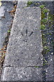
Benchmark on kerb of Humphrey Burton's Road
Ordnance Survey rivet benchmark described on the Bench Mark Database at http://www.bench-marks.org.uk/bm75256
Image: © Roger Templeman
Taken: 3 May 2016
0.11 miles
10
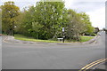
Junction of Leamington Road and Humphrey Burton's Road
There is an OS benchmark Image on a kerbstone near the lamppost in front of the road name sign
Image: © Roger Templeman
Taken: 3 May 2016
0.11 miles