IMAGES TAKEN NEAR TO
Carthusian Road, COVENTRY, CV3 6HA
Introduction
This page details the photographs taken nearby to Carthusian Road, CV3 6HA by members of the Geograph project.
The Geograph project started in 2005 with the aim of publishing, organising and preserving representative images for every square kilometre of Great Britain, Ireland and the Isle of Man.

There are currently over 7.5m images from over14,400 individuals and you can help contribute to the project by visiting https://www.geograph.org.uk
Image Map
Images are licensed for reuse under creativecommons.org/licenses/by-sa/2.0
Notes
- Clicking on the map will re-center to the selected point.
- The higher the marker number, the further away the image location is from the centre of the postcode.
Image Listing (59 Images Found)
Images are licensed for reuse under creativecommons.org/licenses/by-sa/2.0
Image
Details
Distance
1
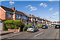
Franciscan Road
c.1920s/30s housing, first shown on the 1940 25 inch map.
Image: © Ian Capper
Taken: 24 Sep 2021
0.04 miles
2
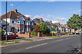
Daventry Road
c.1920s/30s housing, some first shown on the 1940 25 inch map.
Image: © Ian Capper
Taken: 24 Sep 2021
0.05 miles
4
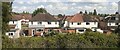
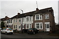
Semi detached houses on Daventry Road
Image: © Roger Templeman
Taken: 10 Mar 2018
0.06 miles
5
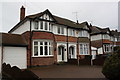
Houses on Benedictine Road
There is an OS benchmark Image on the side of the right hand house beside its metal gate
Image: © Roger Templeman
Taken: 10 Mar 2018
0.07 miles
6
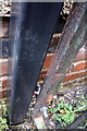
Benchmark behind gate of #27 Benedictine Road
Ordnance Survey cut mark benchmark described on the Bench Mark Database at http://www.bench-marks.org.uk/bm93916
Image: © Roger Templeman
Taken: 10 Mar 2018
0.07 miles
7
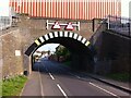
Low and narrow railway bridge over The Hiron, Cheylesmore
The bridge carries the Coventry-Leamington railway over the road. The container at the top of the picture belongs to a goods train that is crossing the bridge. The railway opened in 1844. https://en.wikipedia.org/wiki/Coventry%E2%80%93Leamington_line
Image: © A J Paxton
Taken: 9 May 2016
0.07 miles
8
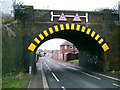
The Hiron Rail Bridge
A double decker bus tried to fit through this rail bridge but failed! - therefore it has been painted recently in vibrant yellow/black colours.
Image: © John Curran
Taken: 13 Feb 2006
0.08 miles
9
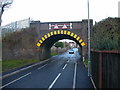
Coventry-The Hiron Bridge
Carrying the Line to Leamington.
Image: © Ian Rob
Taken: 14 Nov 2007
0.08 miles
10
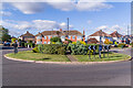
Roundabout, Daventry Road
Roundabout at the junction of Daventry Road and Ulverscroft Road. The road layout and some of the housing are first shown on the 1940 25 inch map.
Image: © Ian Capper
Taken: 24 Sep 2021
0.10 miles