IMAGES TAKEN NEAR TO
Armorial Road, COVENTRY, CV3 6GH
Introduction
This page details the photographs taken nearby to Armorial Road, CV3 6GH by members of the Geograph project.
The Geograph project started in 2005 with the aim of publishing, organising and preserving representative images for every square kilometre of Great Britain, Ireland and the Isle of Man.

There are currently over 7.5m images from over14,400 individuals and you can help contribute to the project by visiting https://www.geograph.org.uk
Image Map
Images are licensed for reuse under creativecommons.org/licenses/by-sa/2.0
Notes
- Clicking on the map will re-center to the selected point.
- The higher the marker number, the further away the image location is from the centre of the postcode.
Image Listing (112 Images Found)
Images are licensed for reuse under creativecommons.org/licenses/by-sa/2.0
Image
Details
Distance
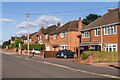
1
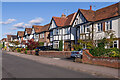
Armorial Road
Houses on a road first marked on the 1940 25 inch map.
Image: © Ian Capper
Taken: 24 Sep 2021
0.01 miles
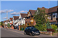
2
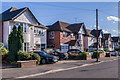
Armorial Road
Houses on a road first marked on the 1940 25 inch map.
Image: © Ian Capper
Taken: 24 Sep 2021
0.04 miles
3
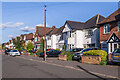
Armorial Road
Houses on a road first marked on the 1940 25 inch map.
Image: © Ian Capper
Taken: 24 Sep 2021
0.05 miles
4
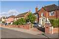
Armorial Road
Houses on a road first marked on the 1940 25 inch map.
Image: © Ian Capper
Taken: 24 Sep 2021
0.05 miles
5
Armorial Road
Houses on a road first marked on the 1940 25 inch map.
Image: © Ian Capper
Taken: 24 Sep 2021
0.06 miles
6
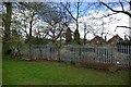
Cattle troughs in War Memorial Park
Hidden away next to the boundary fence are two disused cattle troughs, both inscribed "Metropolitan Drinking Fountain & Cattle Trough Association". The far trough has the inscription facing the fence.
The railway runs on the other side of the fence, while in the background can be seen houses on Armorial Road.
Image: © Keith Williams
Taken: 12 Apr 2008
0.07 miles
7
Armorial Road
Houses on a road first marked on the 1940 25 inch map.
Image: © Ian Capper
Taken: 24 Sep 2021
0.07 miles
8
Armorial Road
Houses on a road first marked on the 1940 25 inch map.
Image: © Ian Capper
Taken: 24 Sep 2021
0.07 miles
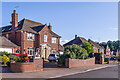
9
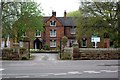
Styvechale Grange
This house was probably built around 1650, long before the more recent developments that surround it.
Image: © Keith Williams
Taken: 9 Apr 2009
0.08 miles
10
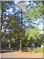
Memorial tree
A War Memorial Park beech planted in memory of Private 34656 Arthur Lewin Marshall Bull of the 2nd Oxford & Bucks L.I. who died in World War I on 5/10/1918 aged 19.
Image: © E Gammie
Taken: 29 Oct 2018
0.10 miles