IMAGES TAKEN NEAR TO
Baginton Road, COVENTRY, CV3 6FX
Introduction
This page details the photographs taken nearby to Baginton Road, CV3 6FX by members of the Geograph project.
The Geograph project started in 2005 with the aim of publishing, organising and preserving representative images for every square kilometre of Great Britain, Ireland and the Isle of Man.

There are currently over 7.5m images from over14,400 individuals and you can help contribute to the project by visiting https://www.geograph.org.uk
Image Map
Images are licensed for reuse under creativecommons.org/licenses/by-sa/2.0
Notes
- Clicking on the map will re-center to the selected point.
- The higher the marker number, the further away the image location is from the centre of the postcode.
Image Listing (2 Images Found)
Images are licensed for reuse under creativecommons.org/licenses/by-sa/2.0
Image
Details
Distance
1
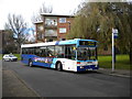
Confused bus, Charminster Drive, Fenside
This Mercedes O.405N, operated by National Express Coventry, appears to know where it's going, but seems confused about how to get there. "City Centre via Cheylesmore" would be more appropriate.
Image: © Richard Vince
Taken: 10 Nov 2012
0.24 miles
2
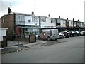
Shopping Parade in Dawlish Drive
Shops at the end of Knoll Drive.
Image: © Ian Rob
Taken: 10 Oct 2009
0.25 miles