IMAGES TAKEN NEAR TO
Main Street, SHIPSTON-ON-STOUR, CV36 5JG
Introduction
This page details the photographs taken nearby to Main Street, CV36 5JG by members of the Geograph project.
The Geograph project started in 2005 with the aim of publishing, organising and preserving representative images for every square kilometre of Great Britain, Ireland and the Isle of Man.

There are currently over 7.5m images from over14,400 individuals and you can help contribute to the project by visiting https://www.geograph.org.uk
Image Map
Images are licensed for reuse under creativecommons.org/licenses/by-sa/2.0
Notes
- Clicking on the map will re-center to the selected point.
- The higher the marker number, the further away the image location is from the centre of the postcode.
Image Listing (40 Images Found)
Images are licensed for reuse under creativecommons.org/licenses/by-sa/2.0
Image
Details
Distance
4
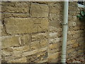
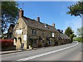
Nineteenth-century benchmark on the Red Lion
This bench mark was established between 1850 and 1856 during the First primary levelling of England & Wales, and was levelled with a height of 376.0090 feet [114.6075 metres] above mean sea level (Liverpool datum). It was included on the Basingstoke to Coventry levelling line. The surveyor's description was "No. 150. Mark on the front of the Red Lion Inn, Long Compton Village; 2.78 ft. above surface." (Public Abstract p.238)
Image: © Shantavira
Taken: 10 Oct 2015
0.05 miles
5
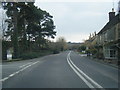
Long Compton-The Red Lion
At the south end of the village.
Image: © Ian Rob
Taken: 15 May 2019
0.05 miles
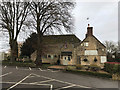
6
The Red Lion, Long Compton
The A3400 passes by.
Image: © Robin Webster
Taken: 11 Aug 2019
0.06 miles
7
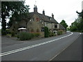
Long Compton, The Red Lion
2009 Good Beer Guide-listed Cotswolds stone pub on Main Street (A3400). Internally, wooden beams & stone walls; long bar with drinking areas to the front, eating to the left & right. Cask ales on offer at my visit: Hook Norton Hooky, Cameron Strongarm.
Image: © Mike Faherty
Taken: 11 Jul 2009
0.06 miles
9
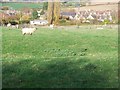
Common fields met here once
In the Middle Ages, each village had several common fields. The fields were ploughed in strips creating the "ridge and furrow" pattern so often seen in the North Cotswolds. Here is an excellent example of the boundary between two common fields and the nearest sheep is standing on the boundary. Immediately in front of the camera, this field has been ploughed in an east-west direction whilst beyond the sheep would have been another common field where the ploughing is in a north-south direction.
Image: © Michael Dibb
Taken: 26 Oct 2009
0.11 miles
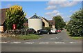
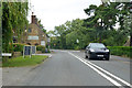
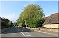
10
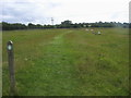
Shakespeare's Way
Shakespeare's Way heading out from Long Compton to South Hill Farm
Image: © Shaun Ferguson
Taken: 4 Jul 2014
0.11 miles