IMAGES TAKEN NEAR TO
Kent Close, COVENTRY, CV3 5PS
Introduction
This page details the photographs taken nearby to Kent Close, CV3 5PS by members of the Geograph project.
The Geograph project started in 2005 with the aim of publishing, organising and preserving representative images for every square kilometre of Great Britain, Ireland and the Isle of Man.

There are currently over 7.5m images from over14,400 individuals and you can help contribute to the project by visiting https://www.geograph.org.uk
Image Map
Images are licensed for reuse under creativecommons.org/licenses/by-sa/2.0
Notes
- Clicking on the map will re-center to the selected point.
- The higher the marker number, the further away the image location is from the centre of the postcode.
Image Listing (36 Images Found)
Images are licensed for reuse under creativecommons.org/licenses/by-sa/2.0
Image
Details
Distance
1
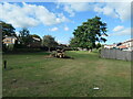
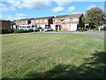
Open space between Black Prince Avenue and Crecy Road
With one less mature tree than there used to be.
Image: © Christine Johnstone
Taken: 24 Sep 2021
0.05 miles
2
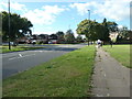
Junction of Black Prince Avenue and Poitiers Road
The cyclist is heading north-west towards Coventry city centre.
Image: © Christine Johnstone
Taken: 24 Sep 2021
0.06 miles
3
Houses in Rosegreen Close, Coventry
Modern semis off William Bristow Road.
Image: © Christine Johnstone
Taken: 24 Sep 2021
0.06 miles
4
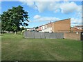
Low-rise flats on Black Prince Avenue
In the southern Coventry suburb of Cheylesmore.
Image: © Christine Johnstone
Taken: 24 Sep 2021
0.08 miles
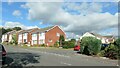
5
2 - 12 Rosegreen Close, Coventry
Off William Bristow Road, in the southern suburb of Cheylesmore.
Image: © Christine Johnstone
Taken: 24 Sep 2021
0.08 miles
6
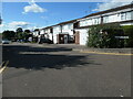
1 -17 Esher Drive, Cheylesmore, Coventry
Semis with integral garages, off William Bristow Road.
Image: © Christine Johnstone
Taken: 24 Sep 2021
0.11 miles
7
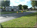
Houses of different styles, William Bristow Road
The houses on the right are 20 or 30 years older than those on the left.
Image: © Christine Johnstone
Taken: 24 Sep 2021
0.12 miles
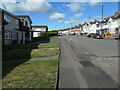
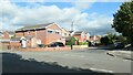
8
Semis climbing William Bristow Road, Coventry
Just north of the junction with Seneschal Road, in the southern Coventry suburb of Cheylesmore.
Image: © Christine Johnstone
Taken: 24 Sep 2021
0.12 miles
9
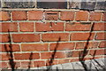
Benchmark on #75 William Bristow Road
Ordnance Survey cut mark benchmark described on the Bench Mark Database at www.bench-marks.org.uk/bm86457
Image: © Roger Templeman
Taken: 6 Jul 2017
0.13 miles
10
The Park Paling, Coventry
A suburban road off William Bristow Road.
Image: © Christine Johnstone
Taken: 24 Sep 2021
0.13 miles