IMAGES TAKEN NEAR TO
Cecily Road, COVENTRY, CV3 5LA
Introduction
This page details the photographs taken nearby to Cecily Road, CV3 5LA by members of the Geograph project.
The Geograph project started in 2005 with the aim of publishing, organising and preserving representative images for every square kilometre of Great Britain, Ireland and the Isle of Man.

There are currently over 7.5m images from over14,400 individuals and you can help contribute to the project by visiting https://www.geograph.org.uk
Image Map
Images are licensed for reuse under creativecommons.org/licenses/by-sa/2.0
Notes
- Clicking on the map will re-center to the selected point.
- The higher the marker number, the further away the image location is from the centre of the postcode.
Image Listing (63 Images Found)
Images are licensed for reuse under creativecommons.org/licenses/by-sa/2.0
Image
Details
Distance
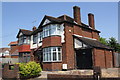
1
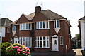
Nos. 206 and 204 Daventry Road
There is an Ordnance Survey benchmark Image on the side of the right hand house about 2 feet from its front corner
Image: © Roger Templeman
Taken: 6 Jul 2017
0.05 miles
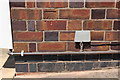
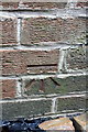
2
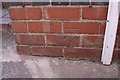
Benchmark on #204 Daventry Road
Ordnance Survey cut mark benchmark described on the Bench Mark Database at www.bench-marks.org.uk/bm86458
Image: © Roger Templeman
Taken: 6 Jul 2017
0.05 miles
3
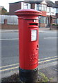
George VI postbox on The Mount, Cheylesmore, Coventry
Postbox No. CV3 293.
See Image] for context.
Image: © JThomas
Taken: 19 Nov 2016
0.09 miles
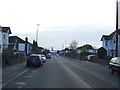
4
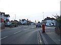
The Mount, Cheylesmore, Coventry
Showing position of Postbox No. CV3 293.
See Image] for postbox.
Image: © JThomas
Taken: 19 Nov 2016
0.09 miles
5
Benchmark on #281 Daventry Road
Ordnance Survey cut mark benchmark described on the Bench Mark Database at www.bench-marks.org.uk/bm86455
Image: © Roger Templeman
Taken: 6 Jul 2017
0.09 miles
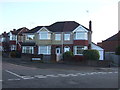
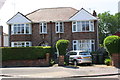
6
#2 The Mount and #281 Daventry Road
There is an Ordnance Survey benchmark Image on the wall of the nearer house between the white utility cabinet and the black garage door.
Image: © Roger Templeman
Taken: 6 Jul 2017
0.10 miles
9
Benchmark on #10 Cecily Road
Ordnance Survey cut mark benchmark described on the Bench Mark Database at www.bench-marks.org.uk/bm86459
Image: © Roger Templeman
Taken: 6 Jul 2017
0.10 miles
10
#2 Woodstock Road and #10 Cecily Road
There is an Ordnance Survey benchmark Image on the side of the right hand house near its front corner
Image: © Roger Templeman
Taken: 6 Jul 2017
0.10 miles