IMAGES TAKEN NEAR TO
Quinton Park, COVENTRY, CV3 5HZ
Introduction
This page details the photographs taken nearby to Quinton Park, CV3 5HZ by members of the Geograph project.
The Geograph project started in 2005 with the aim of publishing, organising and preserving representative images for every square kilometre of Great Britain, Ireland and the Isle of Man.

There are currently over 7.5m images from over14,400 individuals and you can help contribute to the project by visiting https://www.geograph.org.uk
Image Map
Images are licensed for reuse under creativecommons.org/licenses/by-sa/2.0
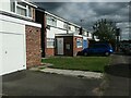
Notes
- Clicking on the map will re-center to the selected point.
- The higher the marker number, the further away the image location is from the centre of the postcode.
Image Listing (38 Images Found)
Images are licensed for reuse under creativecommons.org/licenses/by-sa/2.0
Image
Details
Distance
1
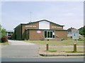
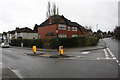
Baptist Church, Quinton Park, Cheylesmore, Coventry
Image: © John Curran
Taken: 1 Jul 2006
0.03 miles
2
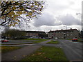
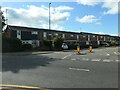
South end of Quinton Park, Coventry
After passing the park itself, the road called Quinton Park swings east to pass in front of a parade of shops.
Image: © Richard Vince
Taken: 10 Nov 2012
0.07 miles
3
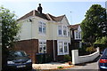
Nos. 10 and 8 Montalt Road
Ordnance Survey documents indicate that in 1959 a benchmark levelled at 76.621m above Newlyn Datum was verified on the SE (side) face of the left hand house. The house may since have been extended on that face.
Image: © Roger Templeman
Taken: 6 Jul 2017
0.09 miles
4
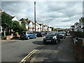
Mary Herbert Street, Coventry
Looking south from the junction with Brightwalton Road. The street was developed after 1937.
Image: © Christine Johnstone
Taken: 24 Sep 2021
0.10 miles
5
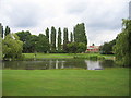
Quinton Park, Cheylesmore
This public green area and lake provide a welcome open space in a square dominated by housing development.
Image: © David Stowell
Taken: 30 Jul 2005
0.11 miles
6
Ulverscroft Road, Coventry
Looking north from the junction with a road called The Chesils.
Image: © Christine Johnstone
Taken: 24 Sep 2021
0.12 miles
7
Junction of The Chesils and Arundel Road
Image: © Roger Templeman
Taken: 10 Mar 2018
0.12 miles
8
Houses on the west side of Ulverscroft Road
The newer houses on this suburban street in Coventry were built with garages, the older ones were not.
Image: © Christine Johnstone
Taken: 24 Sep 2021
0.13 miles
9
Houses on the east side of Ulverscroft Road, Coventry
Built with garages, some of which have been converted.
Image: © Christine Johnstone
Taken: 24 Sep 2021
0.13 miles
10
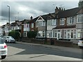
Houses on the west side of Arundel Road, Coventry
Built in blocks of four and six, after 1937.
Image: © Christine Johnstone
Taken: 24 Sep 2021
0.13 miles