IMAGES TAKEN NEAR TO
Glover Street, COVENTRY, CV3 5FZ
Introduction
This page details the photographs taken nearby to Glover Street, CV3 5FZ by members of the Geograph project.
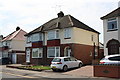
The Geograph project started in 2005 with the aim of publishing, organising and preserving representative images for every square kilometre of Great Britain, Ireland and the Isle of Man.

There are currently over 7.5m images from over14,400 individuals and you can help contribute to the project by visiting https://www.geograph.org.uk
Image Map
Images are licensed for reuse under creativecommons.org/licenses/by-sa/2.0
Notes
- Clicking on the map will re-center to the selected point.
- The higher the marker number, the further away the image location is from the centre of the postcode.
Image Listing (66 Images Found)
Images are licensed for reuse under creativecommons.org/licenses/by-sa/2.0
Image
Details
Distance
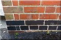
1
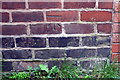
Benchmark on #30 The Martyrs' Close
Ordnance Survey cut mark benchmark described on the Bench Mark Database at http://www.bench-marks.org.uk/bm86345
Image: © Roger Templeman
Taken: 6 Jul 2017
0.07 miles
2
Houses on The Martyrs' Close
There is an OS benchmark Image on the side of the nearest house at its front corner at the junction with the brick wall
Image: © Roger Templeman
Taken: 6 Jul 2017
0.07 miles
3
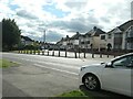
Traffic management, Benedictine Road, Coventry
The junction with Quinton Road has been blocked [for vehicles, but not pedestrians].
Image: © Christine Johnstone
Taken: 24 Sep 2021
0.07 miles
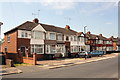
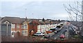
4
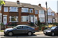
Houses on Quinton Road, Coventry
Built between 1924 and 1937. They look like typical 1930s semis, but they are in blocks of four, not two.
Image: © Christine Johnstone
Taken: 24 Sep 2021
0.08 miles
5
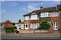
Nos. 49 & 51 The Martyrs' Close
The extension to the left hand house has probably meant the loss of the Ordnance Survey benchmark which was on the front corner of the house
Image: © Roger Templeman
Taken: 6 Jul 2017
0.08 miles
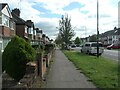
7
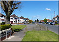
Quinton Road in Cheylesmore, Coventry
The road is heading north towards Coventry city centre.
Image: © Mat Fascione
Taken: 18 Apr 2015
0.08 miles
8
Benchmark on #6 Benedictine Road
Ordnance Survey cut mark benchmark described on the Bench Mark Database at www.bench-marks.org.uk/bm86460
Image: © Roger Templeman
Taken: 6 Jul 2017
0.09 miles
9
Nos. 6 and 8 Benedictine Road
There is an Ordnance Survey benchmark Image on the near side of the right hand house at its front corner
Image: © Roger Templeman
Taken: 6 Jul 2017
0.09 miles
10
Houses of The Martyrs' Close
There is an OS benchmark Image on the right hand brick gatepost of the two visible between the parked cars
Image: © Roger Templeman
Taken: 6 Jul 2017
0.10 miles