IMAGES TAKEN NEAR TO
Palermo Avenue, COVENTRY, CV3 5EH
Introduction
This page details the photographs taken nearby to Palermo Avenue, CV3 5EH by members of the Geograph project.
The Geograph project started in 2005 with the aim of publishing, organising and preserving representative images for every square kilometre of Great Britain, Ireland and the Isle of Man.

There are currently over 7.5m images from over14,400 individuals and you can help contribute to the project by visiting https://www.geograph.org.uk
Image Map
Images are licensed for reuse under creativecommons.org/licenses/by-sa/2.0
Notes
- Clicking on the map will re-center to the selected point.
- The higher the marker number, the further away the image location is from the centre of the postcode.
Image Listing (16 Images Found)
Images are licensed for reuse under creativecommons.org/licenses/by-sa/2.0
Image
Details
Distance
1
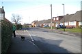
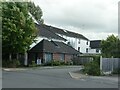
Okehampton Road, Stivichall, Coventry
One of several residential roads with Devonshire and West Country names.
Image: © Robin Stott
Taken: 17 Feb 2015
0.13 miles
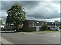
2
Dillotford Avenue
This is close to the eastern end of the avenue. These semi detached houses are opposite Cascade Close.
Image: © Nigel Mykura
Taken: 11 Jun 2011
0.14 miles
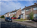
3
Bungalows on the south side of Arundel Road
In the Coventry suburb of Cheylesmore.
Image: © Christine Johnstone
Taken: 24 Sep 2021
0.14 miles
4
1-9 Bettman Close, Coventry
In the southern suburb of Cheylesmore. Probably built in the 1970s.
Image: © Christine Johnstone
Taken: 24 Sep 2021
0.15 miles
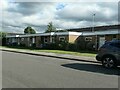
5
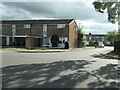
Royce Court, off Arundel Road, Coventry
The block of flats includes apartments for people with disabilities living independently.
Image: © Christine Johnstone
Taken: 24 Sep 2021
0.15 miles
6
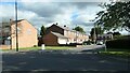
Chatsworth Rise, Stivichall, Coventry
Seen from Okehampton Road.
Image: © Robin Stott
Taken: 17 Feb 2015
0.17 miles
7
Queen Philippa Street, Coventry
An L-shaped road off Arundel Road.
Image: © Christine Johnstone
Taken: 24 Sep 2021
0.18 miles
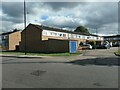
8
1 - 19 Forester's Road, Coventry
Semi-detached house off Arundel Road, Cheylesmore.
Image: © Christine Johnstone
Taken: 24 Sep 2021
0.19 miles
9
The east side of Keviliok Street, Coventry
Seen from the junction with Aruundel Road. The unbuilt Keviliok Street is shown on the 6 inch OS map surveyed in 1937, but these houses were not built until the late 1960s, or later.
Image: © Christine Johnstone
Taken: 24 Sep 2021
0.20 miles
10
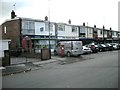
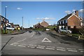
Shopping Parade in Dawlish Drive
Shops at the end of Knoll Drive.
Image: © Ian Rob
Taken: 10 Oct 2009
0.20 miles