IMAGES TAKEN NEAR TO
Stamford Avenue, COVENTRY, CV3 5BX
Introduction
This page details the photographs taken nearby to Stamford Avenue, CV3 5BX by members of the Geograph project.
The Geograph project started in 2005 with the aim of publishing, organising and preserving representative images for every square kilometre of Great Britain, Ireland and the Isle of Man.

There are currently over 7.5m images from over14,400 individuals and you can help contribute to the project by visiting https://www.geograph.org.uk
Image Map
Images are licensed for reuse under creativecommons.org/licenses/by-sa/2.0
Notes
- Clicking on the map will re-center to the selected point.
- The higher the marker number, the further away the image location is from the centre of the postcode.
Image Listing (33 Images Found)
Images are licensed for reuse under creativecommons.org/licenses/by-sa/2.0
Image
Details
Distance
1
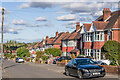
Brayford Avenue
c.1930/40s housing on Brayford Avenue, with the road shown but only with limited development on the 1944 6 inch map. This and neighbouring roads were built on the former grounds of Stivichall Hall.
Image: © Ian Capper
Taken: 24 Sep 2021
0.06 miles
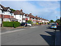
2
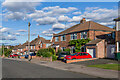
Lupton Avenue
c.1940/50s housing on Lupton Avenue, with the road shown but without development on the 1944 6 inch map and similarly on the 1955 1:10,000 map. This and neighbouring roads were built on the former grounds of Stivichall Hall.
Image: © Ian Capper
Taken: 24 Sep 2021
0.13 miles
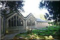
3
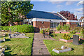
St James's Church Hall
Church hall to St James's Church (see Image), originally built 1939 but since extended.
Image: © Ian Capper
Taken: 24 Sep 2021
0.13 miles
4
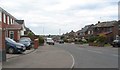
Lupton Avenue
Lupton Avenue drops down towards Cheylesmore from its junction with Knoll Drive.
Image: © E Gammie
Taken: 27 Apr 2020
0.14 miles
5
Coventry-Stivichall Church
Saint James Church in Leamington Road.
Image: © Ian Rob
Taken: 10 Oct 2009
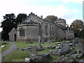
0.15 miles
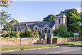
6
St James's Church, Styvechale
An ancient parish church, rebuilt in 1817 and extended in 1955-65.
Image: © E Gammie
Taken: 27 Apr 2020
0.16 miles
7
Church of St James
https://historicengland.org.uk/listing/the-list/list-entry/1139458?section=official-list-entry
Image: © Sandy Gerrard
Taken: 18 Oct 2007
0.16 miles
8
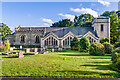
St James's Church
Church with 13th Century origins, but rebuilt 1810-7 by Coventry stonemason James Green for Francis Gregory of Stivichall Hall, resulting in the present chancel and apse (on the left in this photo). It was then remodelled and extended 1955-65 (including the addition of the nave and tower). Grade II listed - see www.historicengland.org.uk/listing/the-list/list-entry/1139458.
Image: © Ian Capper
Taken: 24 Sep 2021
0.16 miles
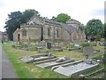
9
Dillottford Avenue
This is a long residential street with semi-detached houses on one side and terraced houses on the other. It runs from the Daventry road all the way round to Black Prince Avenue. The post box on the right is on the corner of Salisbury Avenue.
Image: © Nigel Mykura
Taken: 11 Jun 2011
0.16 miles
10
St James's Church
Church with 13th Century origins, but rebuilt 1810-7 by Coventry stonemason James Green for Francis Gregory of Stivichall Hall, resulting in the present chancel and apse (on the left in this photo). It was then remodelled and extended 1955-65 (including the addition of the nave and tower). Grade II listed - see www.historicengland.org.uk/listing/the-list/list-entry/1139458.
Image: © Ian Capper
Taken: 24 Sep 2021
0.16 miles