IMAGES TAKEN NEAR TO
Wyvern Close, WARWICK, CV35 9TA
Introduction
This page details the photographs taken nearby to Wyvern Close, CV35 9TA by members of the Geograph project.
The Geograph project started in 2005 with the aim of publishing, organising and preserving representative images for every square kilometre of Great Britain, Ireland and the Isle of Man.

There are currently over 7.5m images from over14,400 individuals and you can help contribute to the project by visiting https://www.geograph.org.uk
Image Map
Images are licensed for reuse under creativecommons.org/licenses/by-sa/2.0
Notes
- Clicking on the map will re-center to the selected point.
- The higher the marker number, the further away the image location is from the centre of the postcode.
Image Listing (111 Images Found)
Images are licensed for reuse under creativecommons.org/licenses/by-sa/2.0
Image
Details
Distance
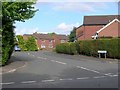
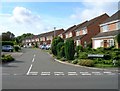
1
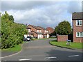
Wyvern Close, Dovehouse Estate
View north along Wyvern Close from its junction with Valletta Way.
Image: © David P Howard
Taken: 20 Sep 2010
0.03 miles
2
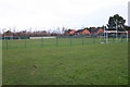
Sports field, Dovehouse Estate
Sports field off Dovehouse Drive, Dovehouse Estate
Image: © David P Howard
Taken: 31 Dec 2009
0.05 miles
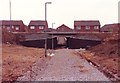
3
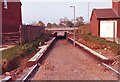
Underpass under Wellesbourne bypass under construction
Compare this view during construction with the current one. Image
Image: © David P Howard
Taken: Unknown
0.06 miles
4
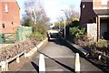
Underpass under the Wellesbourne bypass
Compare this view with the one when the underpass was being constructed. Image
Image: © David P Howard
Taken: 10 Feb 2010
0.06 miles
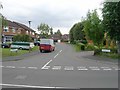
5
Valletta Way, Dovehouse Estate
View NE up Valletta Way from its junction with Dovehouse Drive.
Image: © David P Howard
Taken: 20 Sep 2010
0.07 miles
6
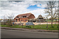
Wellesbourne Sports and Community Centre
The long awaited extension to the Sports Centre is under way. Looking NNW from Loxley Close.
Image: © David P Howard
Taken: 5 Apr 2016
0.07 miles
7
Underpass under Wellesbourne bypass during construction
The underpass joining Valletta Way to Loxley Close during construction. For a view from the other direction see Image
Image: © David P Howard
Taken: Unknown
0.07 miles
8
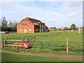
Wellesbourne Sports and Community Centre
This building which stands on the edge of a large recreation ground comprising football and cricket pitches used to be Wellesbourne Football Club. The club went into administration and the building was bought off the administrators by the Parish Council in 2010.
The building is currently being refurbished.
Discussions with a prospective Leisure Management Company to run the premises are ongoing.
Image: © David P Howard
Taken: 30 Apr 2012
0.08 miles
9
Whitworth Close, Dovehouse Estate
View SW up Whitworth Close from its junction with Dovehouse Drive.
Image: © David P Howard
Taken: 20 Sep 2010
0.09 miles
10
Hampdon Way, Dovehouse Estate
Looking south up Hampdon Way from its junction with Dovehouse Drive.
Image: © David P Howard
Taken: 20 Sep 2010
0.10 miles