IMAGES TAKEN NEAR TO
Bridge Street, WARWICK, CV35 9QP
Introduction
This page details the photographs taken nearby to Bridge Street, CV35 9QP by members of the Geograph project.
The Geograph project started in 2005 with the aim of publishing, organising and preserving representative images for every square kilometre of Great Britain, Ireland and the Isle of Man.

There are currently over 7.5m images from over14,400 individuals and you can help contribute to the project by visiting https://www.geograph.org.uk
Image Map
Images are licensed for reuse under creativecommons.org/licenses/by-sa/2.0
Notes
- Clicking on the map will re-center to the selected point.
- The higher the marker number, the further away the image location is from the centre of the postcode.
Image Listing (177 Images Found)
Images are licensed for reuse under creativecommons.org/licenses/by-sa/2.0
Image
Details
Distance
1
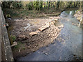
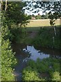
Flood defence works on the River Dene
Just downstream of the Bridge Street bridge over the River Dene. Large stone blocks have been placed, probably to protect the edges of the silt bank from being washed away and causing problems further down stream.
Image: © David P Howard
Taken: 12 Mar 2015
0.03 miles
2
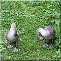
Having a good preen
Two cygnets on a gravel bank in the middle of the River Dene, having a good preen at their slowly whitening plumage.
Taken from the bridge on Bridge Street.
Image: © David P Howard
Taken: 22 Sep 2013
0.03 miles
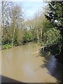
3
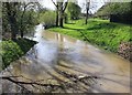
Flood defence banks alongside the River Dene
View south east from the Bridge Street bridge showing the flood defence banks and in the foreground the flood sluice channel. The river level was high after a week of almost continuous rain. Compare with a previous photo taken two years earlier, Image, with much lower water levels.
Image: © David P Howard
Taken: 30 Apr 2012
0.03 miles
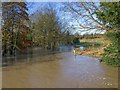
4
Flood defence banks alongside the River Dene
View south east from the Bridge Street bridge showing the edge of the flood defence banks on the far right and in the foreground the flood sluice channel. The river level was high after a week of almost continuous rain. Compare with previous photos with the river at different levels. Image] Image
Image: © David P Howard
Taken: 25 Nov 2012
0.03 miles
5

View upstream from Bridge Street
Looking ESE up the River Dene from the bridge on Bridge Street. After a day of nearly continuous rain, the River Dene has risen overnight and filled the relief channel that passes under the bridge.
Image: © David P Howard
Taken: 7 Feb 2016
0.03 miles
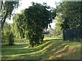
6
River Dene, Wellesbourne
A glimpse of the river from Bridge Street, with sheep grazing beyond and the tower of the church (see http://www.geograph.org.uk/search.php?i=22949957 and Image) beyond. A ford crosses the river here to get into the field; you can see two water depth gauges on the right. I suspect the terrace on the right of Image might be leading away from this ford.
Image: © Derek Harper
Taken: 11 Jun 2011
0.03 miles
7
By the River Dene
Seen from Bridge Street; the bridge over the Dene is a few metres to the left, and the river is similarly out of sight on the left. A belt of green land runs alongside it. Might the terrace / track on the right be leading away from the ford shown in Image?
Image: © Derek Harper
Taken: 11 Jun 2011
0.04 miles
8
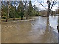
River Dene from the Bridge Street bridge
Looking west from the road bridge. The river level is very high after a week of almost continuous rain. Compare with another view with the river at a lower level. Image
Image: © David P Howard
Taken: 30 Apr 2012
0.04 miles
9
River Dene from the Bridge Street bridge
Looking west from the road bridge. The river level is very high after a week of almost continuous rain. Compare with other views with the river at different levels. Image] Image
Image: © David P Howard
Taken: 25 Nov 2012
0.04 miles
10
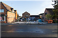
Construction site on Bridge Street
This was the location of a small vehicle repair garage which has been demolished and is now being rebuilt as shop units with accommodation.
Taken during a walk round the village on Xmas Day.
Image: © David P Howard
Taken: 25 Dec 2014
0.05 miles