IMAGES TAKEN NEAR TO
Copeland Avenue, WARWICK, CV35 9LZ
Introduction
This page details the photographs taken nearby to Copeland Avenue, CV35 9LZ by members of the Geograph project.
The Geograph project started in 2005 with the aim of publishing, organising and preserving representative images for every square kilometre of Great Britain, Ireland and the Isle of Man.

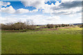
There are currently over 7.5m images from over14,400 individuals and you can help contribute to the project by visiting https://www.geograph.org.uk
Image Map
Images are licensed for reuse under creativecommons.org/licenses/by-sa/2.0
Notes
- Clicking on the map will re-center to the selected point.
- The higher the marker number, the further away the image location is from the centre of the postcode.
Image Listing (112 Images Found)
Images are licensed for reuse under creativecommons.org/licenses/by-sa/2.0
Image
Details
Distance
1
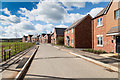
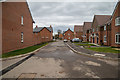
Houses on Copeland Avenue
View SSW along Copeland Avenue on the eastern edge of the Ettington Park Estate.
Image: © David P Howard
Taken: 5 Apr 2016
0.01 miles
2
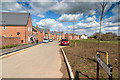
Copeland Avenue, Ettington Park Estate
View north along a row of newly completed houses on the eastern edge of the new housing development.
Image: © David P Howard
Taken: 5 Apr 2016
0.03 miles
3
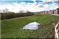
Drainage pond off Copeland Avenue
A surface water drainage pond on the eastern edge of the Ettington Park Estate.
Image: © David P Howard
Taken: 5 Apr 2016
0.03 miles
4
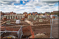
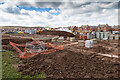
Sheltered housing construction
Construction has started on the sheltered housing development in the centre of the Ettington Park Estate.
View west from the service road at the back of the houses on Copeland Avenue.
Image: © David P Howard
Taken: 5 Apr 2016
0.03 miles
5
Drainage pond on eastern edge of housing estate
View east from Copeland Avenue towards the edge of the Ettington Park Estate.
The depressed area in front of the hedge line is a surface water drainage pond.
Image: © David P Howard
Taken: 5 Apr 2016
0.04 miles
6
Baden West Road, Ettington Park Estate
View NNE along Baden West Road towards the junction with Copeland Avenue.
Image: © David P Howard
Taken: 8 Apr 2016
0.04 miles
7
Sheltered housing construction
Construction has started on the sheltered housing development in the centre of the Ettington Park Estate.
View south west from the service road at the back of the houses on Copeland Avenue.
Image: © David P Howard
Taken: 5 Apr 2016
0.04 miles
8
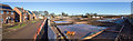
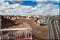
Panoramic view from Grantham Road
This is a stitched 110 degree panorama from seven images, taken using a three metre monopod to secure a high viewing position.
It shows the continued building on the Ettington Park Estate.
Image: © David P Howard
Taken: 18 Jan 2015
0.06 miles
9
Storage yard on Ettington Park Estate
View west from the current end of Copeland Avenue towards the centre of the Ettington Park Estate.
Image: © David P Howard
Taken: 5 Apr 2016
0.07 miles
10
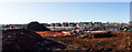
Panoramic view from Walton Lane
This is a stitched 80 degree panorama from four images, taken using a three metre monopod to secure a high viewing position.
It shows the continued building on the Ettington Park Estate.
Image: © David P Howard
Taken: 18 Jan 2015
0.08 miles