
IMAGES TAKEN NEAR TO
Grantham Road, WARWICK, CV35 9AJ
Introduction
This page details the photographs taken nearby to Grantham Road, CV35 9AJ by members of the Geograph project.
The Geograph project started in 2005 with the aim of publishing, organising and preserving representative images for every square kilometre of Great Britain, Ireland and the Isle of Man.

There are currently over 7.5m images from over14,400 individuals and you can help contribute to the project by visiting https://www.geograph.org.uk
Image Map
Images are licensed for reuse under creativecommons.org/licenses/by-sa/2.0
Notes
- Clicking on the map will re-center to the selected point.
- The higher the marker number, the further away the image location is from the centre of the postcode.
Image Listing (108 Images Found)
Images are licensed for reuse under creativecommons.org/licenses/by-sa/2.0
Image
Details
Distance
1
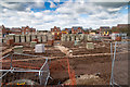
Sheltered housing construction
Construction has started on the sheltered housing development in the centre of the Ettington Park Estate.
View west from the service road at the back of the houses on Copeland Avenue.
Image: © David P Howard
Taken: 5 Apr 2016
0.02 miles
2
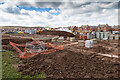
Sheltered housing construction
Construction has started on the sheltered housing development in the centre of the Ettington Park Estate.
View south west from the service road at the back of the houses on Copeland Avenue.
Image: © David P Howard
Taken: 5 Apr 2016
0.02 miles
3

Fields east of Ettington Road
Currently farmland but subject to new housing development.
Image: © David P Howard
Taken: 15 May 2013
0.04 miles
4

Fields east of Ettington Road
The first stage of the new housing development east of Ettington Road is now under way.
This area is being used as a contractor's car park.
In the distance in the field, lines of wooden posts are marking out the outlines of the new estate.
For earlier photos before work started see Image] and Image
Image: © David P Howard
Taken: 1 Sep 2013
0.04 miles
5
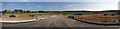
View of new housing development from A429 roundabout
A panoramic view looking east from the new roundabout on the A429 Ettington Road. The work on the new roundabout started on 22nd. July 2013, and is due to take 14 weeks. It is the first stage of a large new housing development east of the A429 on the edge of Wellesbourne.
This will be the entry road onto the new housing estate.
Image: © David P Howard
Taken: 29 Sep 2013
0.04 miles
6
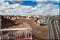
Storage yard on Ettington Park Estate
View west from the current end of Copeland Avenue towards the centre of the Ettington Park Estate.
Image: © David P Howard
Taken: 5 Apr 2016
0.05 miles
7
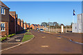
Houses on Grantham Road
Grantham Road on the Ettington Park Estate.
Image: © David P Howard
Taken: 18 Jan 2015
0.05 miles
8
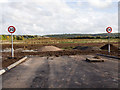
Road to nowhere
View looking east from the new roundabout on the A429 Ettington Road. The work on the new roundabout started on 22nd. July 2013, and is due to take 14 weeks. It is the first stage of a large new housing development east of the A429 on the edge of Wellesbourne.
This will be the entry road onto the new housing estate, and the speed limit signs indicate the end of the highway and the start of the estate.
Image: © David P Howard
Taken: 19 Oct 2013
0.05 miles
9
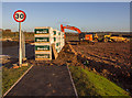
Beginning to lay out internal roads
The new housing development east of the A429, south of Wellesbourne village has reached the stage where the new access roundabout on the A429 is almost completed and materials and plant have arrived to lay out the internal roads.
Image: © David P Howard
Taken: 30 Nov 2013
0.05 miles
10
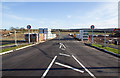
Entrance to the new housing estate
Looking east from the new roundabout on the A429 south of Wellesbourne.
The highway stops at the fence and the estate roads have started to be laid prior to house building commencing.
Compare with Image taken two months earlier.
Image: © David P Howard
Taken: 25 Dec 2013
0.05 miles