IMAGES TAKEN NEAR TO
Wasperton, WARWICK, CV35 8BF
Introduction
This page details the photographs taken nearby to CV35 8BF by members of the Geograph project.
The Geograph project started in 2005 with the aim of publishing, organising and preserving representative images for every square kilometre of Great Britain, Ireland and the Isle of Man.

There are currently over 7.5m images from over14,400 individuals and you can help contribute to the project by visiting https://www.geograph.org.uk
Image Map
Images are licensed for reuse under creativecommons.org/licenses/by-sa/2.0
Notes
- Clicking on the map will re-center to the selected point.
- The higher the marker number, the further away the image location is from the centre of the postcode.
Image Listing (33 Images Found)
Images are licensed for reuse under creativecommons.org/licenses/by-sa/2.0
Image
Details
Distance
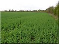
1
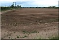
Rapeseed field, Wasperton
A very similar of the field shown in Image, taken just over two months later, with the plants having flowered and seeded in the meantime. Burdock seems to be sprouting up in the foreground. The A429 runs behind the trees on the right.
Image: © Derek Harper
Taken: 10 Jun 2011
0.06 miles
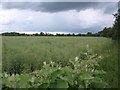
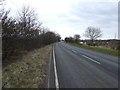
2
Field of crops near Barford.
This field is just to the east of the A429 between Barford and Wellesbourne. The fields are quite rich as they are on the flood plain of the Avon which is only a few hundred metres away.
Image: © Nigel Mykura
Taken: 3 Apr 2011
0.07 miles
3
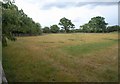
Field, Wasperton
Seen from the side of the no through road into the village, and in the nagle between it and the A429. A diagonal "chamfer" of fencing across the left corner encloses a triangle of woodland. Very gloomy at 7 pm less than two weeks from the summer solstice.
Image: © Derek Harper
Taken: 10 Jun 2011
0.09 miles
4
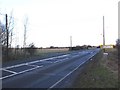
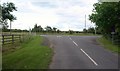
Turn for Wasperton from A429
View North up the A429 at the junction for Wasperton.
Image: © David P Howard
Taken: 21 Feb 2010
0.11 miles
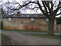
6
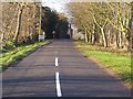
Tilled field, Wasperton
On the other side of a bridleway to Heathcote Farm from Image The A429 runs along the left side.
Image: © Derek Harper
Taken: 10 Jun 2011
0.11 miles
7
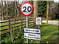
Wasperton village
Signpost for Wasperton; this is the only way into the village.
Image: © D Holte
Taken: 14 Apr 2013
0.13 miles
8
Junction at Wasperton
The reverse view of Image, with the no through road ending in a T-junction at the A429.
Image: © Derek Harper
Taken: 10 Jun 2011
0.13 miles
9
Wasperton no through road.
Not many villages that I know of are in a no through road situation.
Image: © John Holmes
Taken: 8 Dec 2005
0.14 miles