IMAGES TAKEN NEAR TO
Stratford Road, WARWICK, CV35 8AE
Introduction
This page details the photographs taken nearby to Stratford Road, CV35 8AE by members of the Geograph project.
The Geograph project started in 2005 with the aim of publishing, organising and preserving representative images for every square kilometre of Great Britain, Ireland and the Isle of Man.

There are currently over 7.5m images from over14,400 individuals and you can help contribute to the project by visiting https://www.geograph.org.uk
Image Map
Images are licensed for reuse under creativecommons.org/licenses/by-sa/2.0
Notes
- Clicking on the map will re-center to the selected point.
- The higher the marker number, the further away the image location is from the centre of the postcode.
Image Listing (4 Images Found)
Images are licensed for reuse under creativecommons.org/licenses/by-sa/2.0
Image
Details
Distance
1
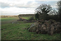
Bridleway past a plantation
The bridleway heads east from Ardenhill Spinney to meet the B4463 just beyond an unnamed plantation. The B4463 crosses the M40, left. Several groups of decaying straw bales provide a foreground at this viewpoint.
Image: © Robin Stott
Taken: 18 Jan 2011
0.22 miles
2
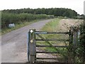
Bridleway to Ardenhill Spinney
From the B4463 just south of the M40. Ardenhill Spinney is hidden by the wood in the photo (unnamed on the map) in Image The route continues to Norton Lindsey.
Image: © Robin Stott
Taken: 8 Oct 2009
0.23 miles
3
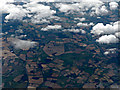
Snitterfield from the air
The M40 motorway is in the foreground, former RAF Snitterfield is obscured by cloud, near the golf course in the centre.
Image: © Thomas Nugent
Taken: 3 Aug 2015
0.24 miles
4
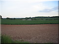
Near Longbridge
Looking across the square to New Barn Farm from the bridle way to Ardenhill Spinney.
Image: © David Stowell
Taken: 29 May 2005
0.25 miles