IMAGES TAKEN NEAR TO
Heath Terrace, WARWICK, CV35 7NR
Introduction
This page details the photographs taken nearby to Heath Terrace, CV35 7NR by members of the Geograph project.
The Geograph project started in 2005 with the aim of publishing, organising and preserving representative images for every square kilometre of Great Britain, Ireland and the Isle of Man.

There are currently over 7.5m images from over14,400 individuals and you can help contribute to the project by visiting https://www.geograph.org.uk
Image Map
Images are licensed for reuse under creativecommons.org/licenses/by-sa/2.0
Notes
- Clicking on the map will re-center to the selected point.
- The higher the marker number, the further away the image location is from the centre of the postcode.
Image Listing (21 Images Found)
Images are licensed for reuse under creativecommons.org/licenses/by-sa/2.0
Image
Details
Distance
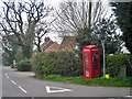
1
House at crossroad near Beausale
I wonder how ‘Dirty Lane’ got its name.
Image: © Alan Hughes
Taken: 25 Sep 2021
0.04 miles
5
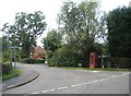
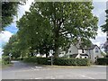
Beausale
The crossroads at the middle of the village along with the listing red phone box.
Image: © David Stowell
Taken: 3 Sep 2005
0.05 miles
6
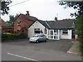
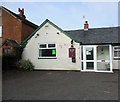
Beausale Village Club
Although the village does not have a pub as such, it does have this club which also acts as the local community centre.
Image: © David Stowell
Taken: 3 Sep 2005
0.05 miles
7
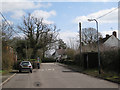
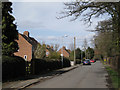
Heath Terrace, Beausale
Approaching the crossroads
Image: © Robin Stott
Taken: 21 Mar 2010
0.05 miles
8
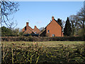
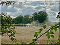
Gable ends, Beausale
Looking north from Butlers End.
Image: © Robin Stott
Taken: 1 Apr 2010
0.06 miles