IMAGES TAKEN NEAR TO
Hughes Hill, WARWICK, CV35 7AS
Introduction
This page details the photographs taken nearby to Hughes Hill, CV35 7AS by members of the Geograph project.
The Geograph project started in 2005 with the aim of publishing, organising and preserving representative images for every square kilometre of Great Britain, Ireland and the Isle of Man.

There are currently over 7.5m images from over14,400 individuals and you can help contribute to the project by visiting https://www.geograph.org.uk
Image Map
Images are licensed for reuse under creativecommons.org/licenses/by-sa/2.0
Notes
- Clicking on the map will re-center to the selected point.
- The higher the marker number, the further away the image location is from the centre of the postcode.
Image Listing (36 Images Found)
Images are licensed for reuse under creativecommons.org/licenses/by-sa/2.0
Image
Details
Distance
1
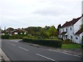
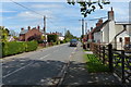
Shrewley
Shrewley is a typical strip development village with houses along the main road with long narrow strip gardens but very little residential housing behind that.
Image: © Nigel Mykura
Taken: 9 Oct 2011
0.09 miles
2
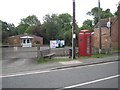
Public domain, Shrewley Common
Village hall and car park (locked: grrrr!), phone box, seat, litter bin and, oh, a public footpath, at the heart of the village. The road is part of the busy route between Five Ways and Claverdon.
Image: © Robin Stott
Taken: 20 Jun 2011
0.15 miles
3
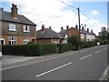
Houses, Shrewley Common
The road is part of the busy route between Five Ways and Claverdon.
Image: © Robin Stott
Taken: 20 Jun 2011
0.16 miles
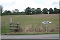
4
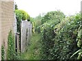
Footpath northwest from Shrewley Common
Leading from the main road to Tunnel Barn Farm and beyond.
Image: © Robin Stott
Taken: 20 Jun 2011
0.16 miles
6
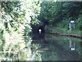
Shrewley Tunnel - Grand Union Canal
This tunnel is 433yds long and the brick lining is now covered with calciferous deposits with hundreds of small stalactites having been formed in this very wet tunnel.
Image: © DACP
Taken: 18 Jul 2007
0.21 miles
7
Sign at Tunnel Barn Farm
"Fishing this way". The farm operates a group of fishing lakes.
Image: © Robin Stott
Taken: 20 Jun 2011
0.21 miles
8
Shrewley Towpath Tunnel
This unusual tunnel, tucked inconspicuously away between houses on Shrewley Common, leads down to the Grand Union Canal and was at one time the route for boats' horses which were led across the top of the hill. Today it provides convenient access for boaters to reach the pub and shop in Shrewley.
Image: © Stephen McKay
Taken: 14 Aug 2015
0.21 miles
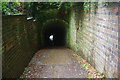
9
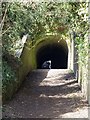
Shrewley Horse Tunnel, Grand Union Canal
The south east entrance to the Shrewley Horse Tunnel. The tunnel is about 40 metres long, and the far end can just be seen in the photo.
A photo of the inside of the tunnel is at Image], and of the other end of the tunnel at Image
Image: © David P Howard
Taken: 3 Apr 2013
0.21 miles
10
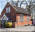
Converted chapel
The heavily weathered, carved plaque on the front reads 1900 (or 1906) Independent Chapel.
The building has been converted for residential use.
Image: © David P Howard
Taken: 3 Apr 2013
0.21 miles