IMAGES TAKEN NEAR TO
Old Warwick Road, WARWICK, CV35 7AA
Introduction
This page details the photographs taken nearby to Old Warwick Road, CV35 7AA by members of the Geograph project.
The Geograph project started in 2005 with the aim of publishing, organising and preserving representative images for every square kilometre of Great Britain, Ireland and the Isle of Man.

There are currently over 7.5m images from over14,400 individuals and you can help contribute to the project by visiting https://www.geograph.org.uk
Image Map
Images are licensed for reuse under creativecommons.org/licenses/by-sa/2.0
Notes
- Clicking on the map will re-center to the selected point.
- The higher the marker number, the further away the image location is from the centre of the postcode.
Image Listing (9 Images Found)
Images are licensed for reuse under creativecommons.org/licenses/by-sa/2.0
Image
Details
Distance
1
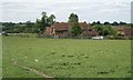
Oldfield Hill Farm
The view from the public footpath in the adjoining field.
Image: © Robin Stott
Taken: 20 Jun 2011
0.03 miles
2
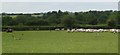
21st-century shepherding
Two dogs, one man and an all-terrain vehicle. The viewpoint is a public footpath in the adjoining field. As I climbed the stile to enter the field this huge flock of sheep surged into it ahead of me. At first I thought this was some Arden-style transhumance but looking back it may have been a shepherding slip-up that made the flock exit the field through a gap in the hedge. Here it has been manoeuvred back into the field it had come from.
Image: © Robin Stott
Taken: 20 Jun 2011
0.05 miles
3
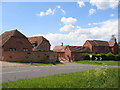
Rowington
Converted farm building beside the Old Warwick Road at Oldfield.
Image: © David Stowell
Taken: 30 May 2005
0.05 miles
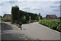
4
Old Warwick Road
Old Warwick Road passing Oldfield Hill Farm heading to Rowington
Image: © Shaun Ferguson
Taken: 22 Sep 2021
0.08 miles
5
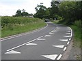
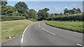
B4439 southeast of Rowington
The fast, twisting Old Warwick Road connects Warwick and Hockley Heath via Rowington and Kingswood.
Image: © Robin Stott
Taken: 20 Jun 2011
0.18 miles
6
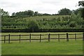
Plantations south of the Old Warwick Road
Image: © Robin Stott
Taken: 20 Jun 2011
0.19 miles
7
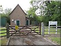
Severn Trent Water's compound
The map identifies this as a pumping station.
Image: © Robin Stott
Taken: 20 Jun 2011
0.24 miles
8
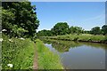
Rowington-Grand Union Canal
Looking back towards Rowington Hill Bridge.
Image: © Ian Rob
Taken: 23 Jun 2021
0.24 miles
9
Drives near High Chimneys Court
High Chimneys Court appears to be an extensive range of converted farm buildings, glimpsed on the left. The Grade II listed High House, formerly High Chimneys, is out of shot, left. The house on the right has not so far been identified. The view is from the public footpath crossing.
Image: © Robin Stott
Taken: 20 Jun 2011
0.25 miles