IMAGES TAKEN NEAR TO
Green Lane, WARWICK, CV35 0RB
Introduction
This page details the photographs taken nearby to Green Lane, CV35 0RB by members of the Geograph project.
The Geograph project started in 2005 with the aim of publishing, organising and preserving representative images for every square kilometre of Great Britain, Ireland and the Isle of Man.

There are currently over 7.5m images from over14,400 individuals and you can help contribute to the project by visiting https://www.geograph.org.uk
Image Map
Images are licensed for reuse under creativecommons.org/licenses/by-sa/2.0
Notes
- Clicking on the map will re-center to the selected point.
- The higher the marker number, the further away the image location is from the centre of the postcode.
Image Listing (78 Images Found)
Images are licensed for reuse under creativecommons.org/licenses/by-sa/2.0
Image
Details
Distance
1
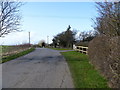
Green Lane
To the right are bungalows and houses, to the left are open fields.
Image: © Michael Dibb
Taken: 3 Mar 2012
0.05 miles
2
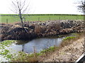
Roadside pond
This small pond is alongside Green Lane.
Image: © Michael Dibb
Taken: 3 Mar 2012
0.05 miles
3
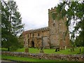
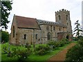
The Parish Church of St Lawrence, Oxhill
The north side of the church taken from the junction of Main Street, Green Lane and Tysoe Road. Further details on the church can be found at http://www.oxhill.org.uk/StLawrence.htm
Image: © David P Howard
Taken: 18 Sep 2010
0.13 miles
4
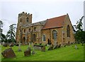
The Parish Church of St Lawrence, Oxhill
The south side of the church from the corner of the churchyard. Further details on the church can be found at http://www.oxhill.org.uk/StLawrence.htm
Image: © David P Howard
Taken: 18 Sep 2010
0.13 miles
5
The Parish Church of St Lawrence, Oxhill
The north side of the church from the entrance to the churchyard off Main Street. Further details on the church can be found at http://www.oxhill.org.uk/StLawrence.htm
Image: © David P Howard
Taken: 18 Sep 2010
0.13 miles
6
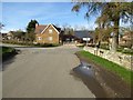
Road junction in Oxhill
Road junction in Oxhill next to the parish church.
Image: © Philip Halling
Taken: 9 Mar 2017
0.14 miles
7
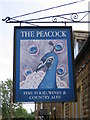
The Peacock sign
There seems to be quite an interest in peacocks in the village of Oxhill. The village pub is named after them ( Image ) and they also appear at the Image
Image: © David Stowell
Taken: 16 Jun 2006
0.15 miles
8
Main Street, Oxhill
From the junction with Green Lane. But the junction with what? Streetview goes for Church Lane, which seems reasonable given the proximity of the church. But the street name sign begs to differ,
Image: © Derek Harper
Taken: 4 Nov 2022
0.16 miles
9
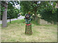
Ethnic scarecrow
An imaginative design as one of the entrants in the village's scarecrow festival.
Image: © David Stowell
Taken: 18 Jun 2006
0.16 miles
10
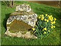
Daffodils beside the remains of a preaching cross
The base of a preaching cross in the churchyard of St Lawrence's church, Oxhill. The cross is Grade II listed.
Historic England description:
Base of preaching cross. Medieval. Ironstone, the angles chamfered. Included for group value.
Source:https://www.historicengland.org.uk/listing/the-list/list-entry/1185848
Image: © Philip Halling
Taken: 9 Mar 2017
0.17 miles