IMAGES TAKEN NEAR TO
Tonbridge Road, COVENTRY, CV3 4AZ
Introduction
This page details the photographs taken nearby to Tonbridge Road, CV3 4AZ by members of the Geograph project.
The Geograph project started in 2005 with the aim of publishing, organising and preserving representative images for every square kilometre of Great Britain, Ireland and the Isle of Man.

There are currently over 7.5m images from over14,400 individuals and you can help contribute to the project by visiting https://www.geograph.org.uk
Image Map
Images are licensed for reuse under creativecommons.org/licenses/by-sa/2.0
Notes
- Clicking on the map will re-center to the selected point.
- The higher the marker number, the further away the image location is from the centre of the postcode.
Image Listing (21 Images Found)
Images are licensed for reuse under creativecommons.org/licenses/by-sa/2.0
Image
Details
Distance
1
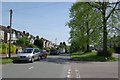
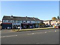
Terrace of five shops, London Road, Whitley, southeast Coventry
From the left they are: Mayfair Chinese Takeaway, Belle Balloons & Florists, The Hairdressing Co, Chai, and Premier Whitley Convenience Store. On the right are houses in Tonbridge Road.
Image: © Robin Stott
Taken: 30 Apr 2016
0.08 miles
2
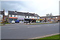
Coventry-Whitley
Parade of Shops on London Road.
Image: © Ian Rob
Taken: 27 Oct 2012
0.08 miles
3
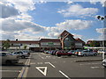
Asda supermarket, Whitley, Coventry
This supermarket (anti-clockwise) was recently converted from a Safeways and is built on the site of the former Whitley Hospital.
Image: © David Stowell
Taken: 15 Jul 2005
0.12 miles
4
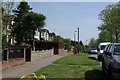
Northwest on London Road, Whitley, southeast Coventry
Towards the city centre. The Abbey Court flats are out-of-shot left; the retaining wall is probably of concrete faced with local stone, random rubble style.
Image: © Robin Stott
Taken: 30 Apr 2016
0.12 miles
5
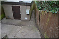
National Grid gas installation by London Road, Whitley, southeast Coventry
Photographed blind over a fence. The grid reference is as noted on a sign.
Image: © Robin Stott
Taken: 30 Apr 2016
0.12 miles
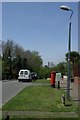
6
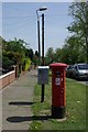
Street furniture in Abbey Road
The postbox is Georgian.
Image: © Keith Williams
Taken: 22 Apr 2009
0.15 miles
9
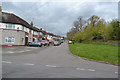
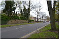
West on Abbey Road, Whitley, southeast Coventry
Abbey Road runs for about a kilometre between the London Road and its severed northwest end near the health club. Behind the trees, right, are Abbey Court flats. The big trees speak of the parkland of the former Whitley Abbey.
Image: © Robin Stott
Taken: 30 Apr 2016
0.17 miles