IMAGES TAKEN NEAR TO
Earls Meadow, WARWICK, CV34 6UA
Introduction
This page details the photographs taken nearby to Earls Meadow, CV34 6UA by members of the Geograph project.
The Geograph project started in 2005 with the aim of publishing, organising and preserving representative images for every square kilometre of Great Britain, Ireland and the Isle of Man.

There are currently over 7.5m images from over14,400 individuals and you can help contribute to the project by visiting https://www.geograph.org.uk
Image Map
Images are licensed for reuse under creativecommons.org/licenses/by-sa/2.0
Notes
- Clicking on the map will re-center to the selected point.
- The higher the marker number, the further away the image location is from the centre of the postcode.
Image Listing (53 Images Found)
Images are licensed for reuse under creativecommons.org/licenses/by-sa/2.0
Image
Details
Distance
1
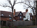
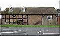
Old House, Stratford Road, Longbridge
Old House is the name, not just a description. Formerly known as Old Manor Farmhouse, consists of a pair of timber framed brick properties dating from c.1600, either side of a later whitewashed structure, and a former barn to the west (now converted to accommodation). Listed grade II (entries 1035416, houses and 1184689, barn).
Image: © Stephen Craven
Taken: 8 Feb 2020
0.03 miles
4
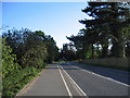
Stratford Road, Longbridge
The bend in the middle distance, actually on the boundary with the next square, marks the point at which the Stratford upon Avon Road used to fork right with the route straight ahead leading to Wellesbourne. With the coming of the M40 the roads were re-aligned and now all through traffic bear right at this point.
Image: © David Stowell
Taken: 28 May 2005
0.05 miles
5
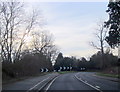
Sharp Bend on A429 Approaching Longbridge Warwick
Image: © Roy Hughes
Taken: 5 Jan 2013
0.05 miles
6
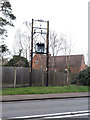
Decommissioned transformer, Stratford Road, Longbridge
This electrical equipment appears to have been stripped of all its cable connections.
Image: © Stephen Craven
Taken: 8 Feb 2020
0.05 miles
9
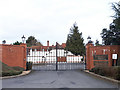
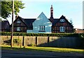
Vehicle entrance to Longbridge Manor
The Manor is a grade II* listed house that dates back to the 14th century (though most of what survives is 16th or early 17th century). It is now prosaically used as the UK office of an American cosmetics company. See also Image
Image: © Stephen Craven
Taken: 8 Feb 2020
0.09 miles
10
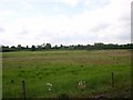
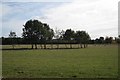
Tournament Fields business park, Warwick
Looking SW from the access road. The business park has hardly been started due to the economic situation. The area is just scrubland at the moment. The buildings in the distance are the rear of the Hilton Hotel by the Longbridge island at the M40 Jnc 15/A46/A429 interchange.
Image: © David P Howard
Taken: 12 May 2010
0.10 miles