IMAGES TAKEN NEAR TO
Stratford Road, WARWICK, CV34 6TW
Introduction
This page details the photographs taken nearby to Stratford Road, CV34 6TW by members of the Geograph project.
The Geograph project started in 2005 with the aim of publishing, organising and preserving representative images for every square kilometre of Great Britain, Ireland and the Isle of Man.

There are currently over 7.5m images from over14,400 individuals and you can help contribute to the project by visiting https://www.geograph.org.uk
Image Map
Images are licensed for reuse under creativecommons.org/licenses/by-sa/2.0
Notes
- Clicking on the map will re-center to the selected point.
- The higher the marker number, the further away the image location is from the centre of the postcode.
Image Listing (71 Images Found)
Images are licensed for reuse under creativecommons.org/licenses/by-sa/2.0
Image
Details
Distance
1
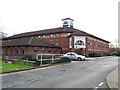
Holiday Inn Express, Longbridge, Warwick
The hotel is convenient for the M40 but also has a bus stop outside on the X18 Coventry-Stratford route, making it equally convenient for tourists.
Image: © Stephen Craven
Taken: 8 Feb 2020
0.02 miles
2
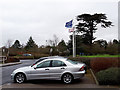
EU flag still flying
This photo was taken during a dry but windy spell in 'Storm Ciara' that battered Britain on 8/9 February 2020. The flags outside the Holiday Inn Express were flying proudly, including that of the EU, which Britain had formally exited a week earlier.
Image: © Stephen Craven
Taken: 9 Feb 2020
0.03 miles
3
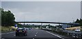
M40 looking south
Looking South, Image is taken from the footbridge you can see in this photo.
Image: © Mike Dodman
Taken: 15 Nov 2016
0.05 miles
4
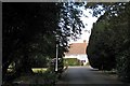
Drive to Longbridge Manor, Warwick
The gardens of Longbridge Manor are of some age and interest. As well as some fine specimen trees there is a circular pool to the east of the house and a long formal pool or canal which may be 17th century or earlier: off to the left in this view.
Image: © Robin Stott
Taken: 4 Oct 2009
0.06 miles
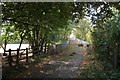
5
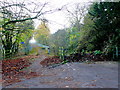
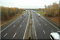
Footbridge over the M40
Over the motorway at Junction 15 of the M40, this bridge enables pedestrian and cyclists to avoid the large busy roundabout bridges at the junction. The footbridge is on the approximate line of the old road prior to the construction of the motor way.
Image: © Nigel Mykura
Taken: 20 Nov 2011
0.06 miles
6
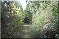
Abandoned length of former A429 near M40 junction 15
The road to Barford and Wellesbourne was severed and diverted by the M40 Image Seen from near Longbridge Manor.
Image: © Robin Stott
Taken: 4 Oct 2009
0.06 miles
7
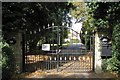
Gates to Longbridge Manor, Warwick
What was the front entrance before the diversion of the A429 Image now appears to be the rear entrance. Longbridge Manor is occupied by a homeopath and franchisees of a cosmetics company.
Image: © Robin Stott
Taken: 4 Oct 2009
0.06 miles
8
Drive to farms near M40 junction 15
Seen from near Longbridge Manor. The drive leads to Longbridge Farm and Home Farm (extending a welcome here). Tree screen in the distance runs alongside the motorway.
Image: © Robin Stott
Taken: 4 Oct 2009
0.06 miles
9
Approach to footbridge over M40 by junction 15
Seen from the end of the driveable part of the former A429 to Barford and Wellesbourne, that was severed by the motorway and diverted Image Seen from the rear of Longbridge Manor.
Image: © Robin Stott
Taken: 4 Oct 2009
0.06 miles