IMAGES TAKEN NEAR TO
Orsino Close, WARWICK, CV34 6FP
Introduction
This page details the photographs taken nearby to Orsino Close, CV34 6FP by members of the Geograph project.
The Geograph project started in 2005 with the aim of publishing, organising and preserving representative images for every square kilometre of Great Britain, Ireland and the Isle of Man.

There are currently over 7.5m images from over14,400 individuals and you can help contribute to the project by visiting https://www.geograph.org.uk
Image Map
Images are licensed for reuse under creativecommons.org/licenses/by-sa/2.0
Notes
- Clicking on the map will re-center to the selected point.
- The higher the marker number, the further away the image location is from the centre of the postcode.
Image Listing (24 Images Found)
Images are licensed for reuse under creativecommons.org/licenses/by-sa/2.0
Image
Details
Distance
1
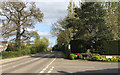
Harbury Lane by Heathcote Park, Royal Leamington Spa
Heathcote Park, entrance, right, is a mature park homes site Image, established many years before the Warwick Gates estate, left. Now new estates are springing up along the south side of Harbury Lane. It's a race track: amid this creeping suburbia the speed limit remains 50mph.
Image: © Robin Stott
Taken: 10 Apr 2017
0.03 miles
2

Get mobile
This mobile home estate has been developed over recent years at Heathcote near Warwick.
Image: © Colin Craig
Taken: 29 Mar 2009
0.06 miles
3
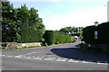
Entrance to Heathcote Park, Harbury Lane, Warwick
A site for permanent mobile homes: Image It was transferred here from Myton to allow the construction of Europa Way in the 1980s.
Image: © Robin Stott
Taken: 11 Aug 2009
0.10 miles
4
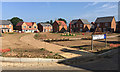
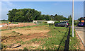
Open space in development, Oakley Grove estate, Heathcote, south Leamington
Oakley Grove is one of the smaller new estates being developed along the south side of Harbury Lane. The developer is local company A.C.Lloyd. In a daring break with tradition all the road names are derived from varieties of potato with royal associations – King Edward Drive, Pentland Crown Place (pictured), Lionheart Avenue, etc – entirely appropriate for a greenfield farm site, it cannot be denied.
Image: © Robin Stott
Taken: 3 Jun 2018
0.12 miles
5
Calpurnia Avenue
All the streets on this large modern housing estate have been given names that come from Shakespeares plays. Calpurnia appears in Julius Caesar. There is also a character of this name in the film "To Kill A Mockingbird"
Image: © Nigel Mykura
Taken: 28 Aug 2011
0.12 miles
6
New residential development south of Harbury Lane, Heathcote, south Leamington
For years the south side of Harbury Lane had a couple of farms and a long-established static caravan site, Heathcote Park Image Planning permission was granted to Gallagher for a business and industrial estate near Europa Way, route to the M40, but it was never implemented. In recent years a number of housing developments have appeared and more are being built. The view is from the new road that will access a site at Grove Farm: Bishops Gate? Oakley Grove? Meadowsweet Farm?
Image: © Robin Stott
Taken: 3 Jun 2018
0.13 miles
7
Caliban Mews, Warwick Gates estate
Almost all the streets on the Warwick Gates estate are named after characters from Shakespeare's plays. Greater familiarity with the Bard's creations might have signalled caution: but, no, we have Timon View, Macbeth Approach, Toby Belch Drive, Cressida Close and - Caliban Mews.
"The isle is full of noises" that do not delight: 4-wheel drives, motorised scooters, light aircraft, lawnmowers, ice-cream vans, drumkits…
Image: © Robin Stott
Taken: 11 Aug 2009
0.13 miles
8
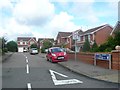
Harbury Lane by Warwick Gates estate
Seen from the corner of Cicero Approach. The identity of this area is in flux. The gazetteer says 'near to Whitnash', which is true, but this corner of Warwick Gates is in the parish of Bishop's Tachbrook, the village to the south. The name Warwick Gates creates an association with Warwick's heritage but the whole estate feels like a further extension of south Leamington. Politically, though, most of the estate is in the Warwick South ward.
Image: © Robin Stott
Taken: 11 Aug 2009
0.14 miles
9
Drive to a former sewage treatment site, Heathcote, south Leamington
Nigel Mykura went a bit further Image and Colin Craig went further still in 2009: Image and Image A full-blown sewage works for Leamington Corporation is first shown here on an OS map of 1939; the house not till 1968. The site is on a low summit, allowing effluent to drain into the Tach Brook, thence to the River Avon above the village of Barford. It became redundant in the 1970s after the opening of the sewage works at Longbridge southwest of Warwick, built to serve both towns (and now operated by Severn Trent Water).
It's not clear how the sewage reached the works. From 1871 Leamington Board of Health had by necessity pumped sewage from the works at Edmondscote Image by a rising main to the Earl of Warwick's land at Heathcote, a rise of 20m over a distance of about 3km, where it was reportedly treated and sold to farmers. Treatment may have consisted of being spread on the land to be naturally irrigated by rain. Old maps show no feature that can be interpreted as a pipeline, yet there were reports of bursts. If it was underground, where did it come to the surface? Did it supply the 1939 works? Alternatively from 1871, could it have been only a short length to an area where solids could be loaded on to carts and conveyed to Heathcote?
Refs: Lyndon F. Cave. Royal Leamington Spa, a history; Phillimore, 2009 ISBN 978-1-86077-505-5
Contemporary newspapers, town council minutes, www.old-maps.co.uk
Image: © Robin Stott
Taken: 3 Jun 2018
0.14 miles
10
South end of Heathcote Park, Harbury Lane, Heathcote
Heathcote Park is a static caravan site. The trees have grown up on the disused Heathcote sewage works to the southwest: see Image The view is from the end of Royal Avenue on one of the new residential developments along the south side of Harbury Lane. 'Royal' is a reference to Jersey Royal potatoes: see Image
Image: © Robin Stott
Taken: 3 Jun 2018
0.15 miles