IMAGES TAKEN NEAR TO
Kirby Avenue, WARWICK, CV34 5YZ
Introduction
This page details the photographs taken nearby to Kirby Avenue, CV34 5YZ by members of the Geograph project.
The Geograph project started in 2005 with the aim of publishing, organising and preserving representative images for every square kilometre of Great Britain, Ireland and the Isle of Man.

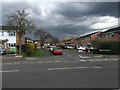
There are currently over 7.5m images from over14,400 individuals and you can help contribute to the project by visiting https://www.geograph.org.uk
Image Map
Images are licensed for reuse under creativecommons.org/licenses/by-sa/2.0
Notes
- Clicking on the map will re-center to the selected point.
- The higher the marker number, the further away the image location is from the centre of the postcode.
Image Listing (47 Images Found)
Images are licensed for reuse under creativecommons.org/licenses/by-sa/2.0
Image
Details
Distance
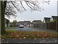
1
Woodloes Avenue North off Primrose Hill, Warwick
Image: © Ian S
Taken: 29 Aug 2019
0.08 miles
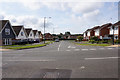
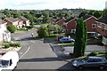
2
Junction of Primrose Hill and Woodloes Avenue North, Warwick
Image: © Robin Stott
Taken: 17 Aug 2009
0.08 miles
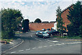
3
Hind Close
This is the truncated end of the cul-de-sac Hind Close viewed from Primrose Hill on the Woodloes Estate. Hind Close is one of several small closes off Kirby Avenue.
Image: © Nigel Mykura
Taken: 19 Nov 2011
0.09 miles
4
Woodloes Lane, Warwick
View NW up Woodloes Lane, the access to Woodloes Farm.
Image: © David P Howard
Taken: 24 Jan 2010
0.12 miles
5
Hicks Close, Woodloes Park, Warwick
Seen from the elevated length of Primrose Hill and looking across the southern area of the estate. The distant light-coloured building, right, is part of Warwick Hospital Image On the skyline, right, is the tower of St Mary's Church.
Image: © Robin Stott
Taken: 17 Aug 2009
0.14 miles
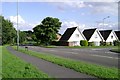
6
Hicks Close, Woodloes Park, Warwick
The high retaining wall supports Primrose Hill, busy distributor road through the estate, opposite its junction with Hathaway Drive.
Image: © Robin Stott
Taken: 15 Sep 2020
0.15 miles
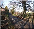
7
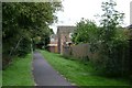
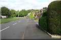
Footpath to the rear of Kettlewell Close, Woodloes Park
An admirable feature of this late-1970s estate is its network of footpaths. Another is its retention of field hedges on the farmland site. This path runs for 500 metres through the southern part of the estate.
Image: © Robin Stott
Taken: 17 Aug 2009
0.15 miles
9
Kettlewell Close off Woodloes Avenue South, Woodloes Park, Warwick
Image: © Robin Stott
Taken: 16 Apr 2016
0.16 miles
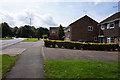
10
Nicholson Close, Woodloes Park, Warwick
Image: © Robin Stott
Taken: 17 Aug 2009
0.18 miles