IMAGES TAKEN NEAR TO
Exham Close, WARWICK, CV34 5UL
Introduction
This page details the photographs taken nearby to Exham Close, CV34 5UL by members of the Geograph project.
The Geograph project started in 2005 with the aim of publishing, organising and preserving representative images for every square kilometre of Great Britain, Ireland and the Isle of Man.

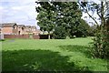
There are currently over 7.5m images from over14,400 individuals and you can help contribute to the project by visiting https://www.geograph.org.uk
Image Map
Images are licensed for reuse under creativecommons.org/licenses/by-sa/2.0
Notes
- Clicking on the map will re-center to the selected point.
- The higher the marker number, the further away the image location is from the centre of the postcode.
Image Listing (110 Images Found)
Images are licensed for reuse under creativecommons.org/licenses/by-sa/2.0
Image
Details
Distance
1
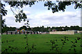
Redevelopment of schools, Woodloes Park estate
There were two schools on the Deansway site. The plan is to demolish the Infants School, enlarge and update the Junior School as a Primary School to accommodate the younger children, and to transfer a special needs school to a new building on the site.
Image: © Robin Stott
Taken: 13 Aug 2009
0.01 miles
2
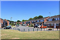
Exham Close, Woodloes Park
Suburban housing on the north side of Warwick. An area of short residential streets and cul de sacs.
Image: © Des Blenkinsopp
Taken: 27 Jun 2018
0.01 miles
3
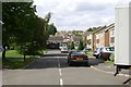
Lincoln Close, Woodloes Park
The ground rises to the north. This view looks across Lowes Avenue and Giffard Way, behind which runs Primrose Hill.
Image: © Robin Stott
Taken: 17 Aug 2009
0.05 miles
4
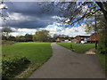
Path ahead through Canalside open space, Woodloes Park, Warwick
On the right are houses in Exham Close. A day of wintry showers.
Image: © Robin Stott
Taken: 16 Apr 2016
0.06 miles
5
Greenspace to the rear of Corbison Close, Woodloes Park
Looking towards the rear of Lowes Avenue.
Image: © Robin Stott
Taken: 17 Aug 2009
0.08 miles
6
East on the Grand Union Canal near The Cape, Warwick
On a bright January afternoon. On the right is the industrial estate off Scar Bank.
Image: © Robin Stott
Taken: 2 Jan 2017
0.08 miles

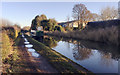
8

Walking the canal towpath below Cape Bottom Lock, north Warwick
On the right is part of the industrial estate north of Millers Road (Ladbroke Park on the A-Z). Behind the camera is the footbridge between Lock Lane and the Woodloes estate Image It was the sunny New Year's Day public holiday, 2 January, New Year's Day having fallen on a Sunday.
Image: © Robin Stott
Taken: 2 Jan 2017
0.09 miles
9
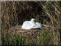
Swan's nest by the canal
A swan sitting on its nest by the side of the Grand Union Canal.
Image: © David P Howard
Taken: 28 Apr 2015
0.09 miles
10
![Warwick canal [6]](https://s1.geograph.org.uk/geophotos/06/62/92/6629281_60d36865_120x120.jpg)
Warwick canal [6]
Sitting on the bank of the canal, the adult swan was attacking everyone walking past her and her six cygnets. The towpath is part of two long distance footpaths - The Grand Union Canal Walk and Shakespeare's Avon Way.
A market town and county town of Warwickshire, Warwick lies on the River Avon, 11 miles (18 kilometres) south of Coventry. There is evidence of unbroken habitation from the 6th century AD with signs of Neolithic and Roman activity before that date. It was a Saxon burh in the 9th century and Warwick Castle was built during the Norman Conquest. Much of the town was destroyed in The Great Fire of Warwick in 1694. Warwick Racecourse is located just west of the town centre. The Grand Union Canal passes through the town and the restored Saltisford Canal Arm is close to the town centre.
Image: © Michael Dibb
Taken: 4 Aug 2020
0.09 miles