IMAGES TAKEN NEAR TO
Lowes Avenue, WARWICK, CV34 5UB
Introduction
This page details the photographs taken nearby to Lowes Avenue, CV34 5UB by members of the Geograph project.
The Geograph project started in 2005 with the aim of publishing, organising and preserving representative images for every square kilometre of Great Britain, Ireland and the Isle of Man.

There are currently over 7.5m images from over14,400 individuals and you can help contribute to the project by visiting https://www.geograph.org.uk
Image Map
Images are licensed for reuse under creativecommons.org/licenses/by-sa/2.0
Notes
- Clicking on the map will re-center to the selected point.
- The higher the marker number, the further away the image location is from the centre of the postcode.
Image Listing (67 Images Found)
Images are licensed for reuse under creativecommons.org/licenses/by-sa/2.0
Image
Details
Distance
1
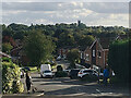
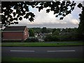
Knoll Drive, Woodloes Park, Warwick
Warwick is a hill town, marked here by the tower of St Mary's Church on the skyline.
This photo replicates the view in Image, the first geograph for this gridsquare, photographed in 2005 by David Stowell. David's estimated location is shown by current large-scale mapping as Kites Close but a visit made clear that it wasn't his viewpoint. Nearby Berwick Close appeared to be the place Image but a careful comparison ruled it out. Some time with Google Streetview identified the road as Knoll Drive. This photo is a cropped version of Image
Image: © Robin Stott
Taken: 1 Oct 2020
0.05 miles
2
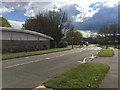
Knoll Drive, Woodloes Park, Warwick
This is the wide view that was cropped to make Image, a re-creation in 2020 of the first geograph for the SP2866 gridsquare, Image taken by David Stowell in 2005. The viewpoint proved to be not the top of Knoll Drive but the footpath up the bank opposite.
Image: © Robin Stott
Taken: 1 Oct 2020
0.05 miles
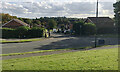
3
Primrose Hill, Woodloes Park, Warwick
One of the arteries of the northern area of the estate. On the right is the junction with Knoll Drive, which appears in an early contribution: Image The sign is dishonest: there are no cameras on this road. However, the contrivance of a mobile speed camera van has been used to justify a rash of these fraudulent signs all over the county. In my view.
Image: © Robin Stott
Taken: 17 Aug 2009
0.06 miles
4
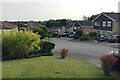
Lincoln Close, Woodloes Park
The ground rises to the north. This view looks across Lowes Avenue and Giffard Way, behind which runs Primrose Hill.
Image: © Robin Stott
Taken: 17 Aug 2009
0.07 miles
5
Primrose Hill and Barnack Drive
With the Tower of St Mary's Church in the distance.
Image: © AJD
Taken: Unknown
0.08 miles
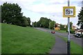
6
Zebra crossing on Deansway, Woodloes Park, Warwick
On the left is the side of the Co-operative Food store.
Image: © Robin Stott
Taken: 16 Apr 2016
0.09 miles
7
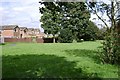
Greenspace to the rear of Corbison Close, Woodloes Park
Looking towards the rear of Lowes Avenue.
Image: © Robin Stott
Taken: 17 Aug 2009
0.09 miles
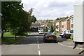
8
Top of Berwick Close, Woodloes Park, Warwick
This photo was an attempt to revisit the location of the first Geograph for the SP2866 square, David Stowell's Image However, it has proved to be the wrong place. It wouldn't be fair to offer as an excuse that everywhere on the Woodloes looks the same but this location does show a marked similarity to the one photographed. The tower of St Mary's Church stands up on the skyline.
Aware of a humming sound I glanced down at the patchy grass to see a swarm of hoverflies or young wasps (I didn't stop to look more closely) that appeared to have emerged from holes in the dry soil.
Image: © Robin Stott
Taken: 15 Sep 2020
0.11 miles
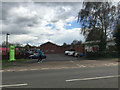
9
Co-operative Food store off Deansway, Woodloes Park, Warwick
The site adjoins Reardon Court shops and the Woodloes Tavern, behind the camera. The location is at a junction of three estate distributor roads. Woodloes Primary School is just along Deansway.
Image: © Robin Stott
Taken: 16 Apr 2016
0.11 miles
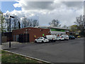
10
Car park for Co-operative Food store off Deansway, Woodloes Park, Warwick
The busy store adjoins the older shops off Reardon Court.
Image: © Robin Stott
Taken: 16 Apr 2016
0.12 miles