IMAGES TAKEN NEAR TO
Greville Road, WARWICK, CV34 5PB
Introduction
This page details the photographs taken nearby to Greville Road, CV34 5PB by members of the Geograph project.
The Geograph project started in 2005 with the aim of publishing, organising and preserving representative images for every square kilometre of Great Britain, Ireland and the Isle of Man.

There are currently over 7.5m images from over14,400 individuals and you can help contribute to the project by visiting https://www.geograph.org.uk
Image Map (Loading...)


Getting Data...Please wait
Leaflet Map data © OpenStreetMap
Images are licensed for reuse under creativecommons.org/licenses/by-sa/2.0
Notes
- Clicking on the map will re-center to the selected point.
- The higher the marker number, the further away the image location is from the centre of the postcode.
Image Listing (379 Images Found)
Images are licensed for reuse under creativecommons.org/licenses/by-sa/2.0
Image
Details
Distance
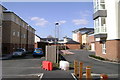
1
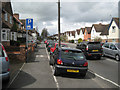
Official off-road parking, Greville Road
A grass verge was sacrificed to avoid hold-ups by parked cars on busy Greville Road. Greville was a family name of the Earls of Warwick.
Image: © Robin Stott
Taken: 22 Apr 2012
0.00 miles
2
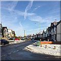
Greville Road, Warwick, in the snow
Greville is a family name of the Earls of Warwick, as in Fulke Greville Image
Image: © Robin Stott
Taken: 12 Dec 2017
0.03 miles
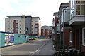
3

Development at Pottertons' site
This is part of the 25 acre site beside the River Avon occupied for over 100 years by Pottertons. Following company mergers production ceased and the site was closed at the turn of this century. It is currently being redeveloped as "Waterside" with blocks of flats and some lower rise housing. The concrete foundations to a further phase of the development can be seen here, just into the adjacent square.
Image: © David Stowell
Taken: 18 Mar 2009
0.04 miles
4
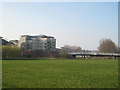
Waterside
The blocks of flats on the site of the former Potterton's factory and the new bridge over the River Avon as seen from Rugby Road. The flood plain in the foreground was used as sports fields by Potterton's social club.
Image: © David Stowell
Taken: 18 Mar 2009
0.04 miles
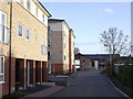
5
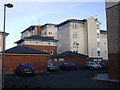
The Waterfront, Warwick
Blocks of flats and garages in assorted sizes, seen from the new Portobello Way at the rear of Greville Road.
Image: © Robin Stott
Taken: 14 Mar 2009
0.04 miles
6
The Waterfront, Warwick
The view down the unfinished Kempton Drive towards the big block of the development.
Image: © Robin Stott
Taken: 15 Mar 2009
0.04 miles
7
Social divide, The Waterfront, Warwick
Social housing, quickly occupied, left. Flats for sale, half-empty, right.
Image: © Robin Stott
Taken: 29 Mar 2009
0.04 miles
8
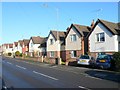
Greville Rd, Emscote
These tightly packed detached modern houses are on the northern outskirts of Warwick close to the boundary with Leamington Spa
Image: © Nigel Mykura
Taken: 2 Jan 2012
0.04 miles
9
Portobello Way, Warwick
Social housing on the less attractive west side of the Waterfront development, built on the site of Potterton's boiler factory and offices.
A new health centre nears completion at the bend of the road.
Image: © Robin Stott
Taken: 14 Mar 2009
0.04 miles
10
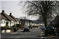
Greville Road, Warwick
A long, busy, monotonous road connecting several residential areas.
Parking on grass verges was so prevalent in the area that the council has paved most of them for residents' use.
Greville was a family name of the Earls of Warwick.
Image: © Robin Stott
Taken: 20 Mar 2009
0.04 miles